


The City of Santa Clarita just celebrated the grand opening of its 38th park, the 10.5-acre Skyline Ranch Park.
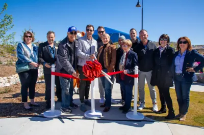
Located in northern Los Angeles County, the City of Santa Clarita has a population of about 229,000, making it the third-most populous city in the county. On April 6, 2024, the City held a grand opening for its 38th park, Skyline Ranch Park. The ceremony featured a brief speaking program followed by the official ribbon-cutting. The 10.5-acre park includes a variety of amenities, including a baseball field, basketball courts, multi-purpose field, a shaded playground with inclusive elements, a half-mile walking path, tennis/pickleball courts, picnic tables, and a brand-new restroom building. The park also offers panoramic views of Santa Clarita.
Skyline Ranch Park is located in a new residential subdivision comprised of more than 1,200 single-family homes. Development for the park began in December 2022, with developer Tri Pointe partnering with the City to create this park. The City of Santa Clarita operates and maintains a wide range of parks to meet the growing and diverse needs of its residents. To learn more, please visit the City's website.
FULL STORY: Community and city officials celebrate opening of Skyline Ranch Park


Bringing Communities Together: Lunar New Year Festivities Across LA County
To celebrate the Lunar New Year, LA County Parks is hosting free community festivals at 61 parks, featuring cultural performances, food tastings, crafts, and interactive activities that honor the Year of the Snake and promote unity and tradition.

Parks as Community Lifelines: Supporting Residents During Times of Crisis
The Los Angeles County Department of Parks and Recreation demonstrates how parks serve as vital community infrastructure by adapting to crises, offering public health services, disaster relief, and essential support for residents in need.
After the Fires: Challenges and Efforts to Heal LA’s Parks and Trails
The recent LA wildfires have devastated parks and trails, with recovery efforts requiring extended closures, collaborative restoration plans, and community support to address extensive damage and long-term risks like landslides.

National Parks Layoffs Will Cause Communities to Lose Billions
Thousands of essential park workers were laid off this week, just before the busy spring break season.

Retro-silient?: America’s First “Eco-burb,” The Woodlands Turns 50
A master-planned community north of Houston offers lessons on green infrastructure and resilient design, but falls short of its founder’s lofty affordability and walkability goals.

Delivering for America Plan Will Downgrade Mail Service in at Least 49.5 Percent of Zip Codes
Republican and Democrat lawmakers criticize the plan for its disproportionate negative impact on rural communities.

Test News Post 1
This is a summary

Test News Headline 46
Test for the image on the front page.

Balancing Bombs and Butterflies: How the National Guard Protects a Rare Species
The National Guard at Fort Indiantown Gap uses GIS technology and land management strategies to balance military training with conservation efforts, ensuring the survival of the rare eastern regal fritillary butterfly.
Urban Design for Planners 1: Software Tools
This six-course series explores essential urban design concepts using open source software and equips planners with the tools they need to participate fully in the urban design process.
Planning for Universal Design
Learn the tools for implementing Universal Design in planning regulations.
EMC Planning Group, Inc.
Planetizen
Planetizen
Mpact (formerly Rail~Volution)
Great Falls Development Authority, Inc.
HUDs Office of Policy Development and Research
NYU Wagner Graduate School of Public Service