


Caltrans will soon close half of the 101 Freeway in order to continue construction of the Wallis Annenberg Wildlife Crossing near Agoura Hills in Los Angeles County.
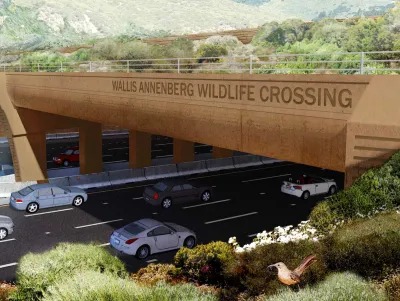
Located at Liberty Canyon and the 101 Freeway, the Wallis Annenberg Wildlife Crossing is a public-private partnership that has leveraged the expertise and leadership of numerous organizations and institutions. The core partners include Caltrans, the National Park Service, the Santa Monica Mountains Conservancy, Mountains Recreation and Conservation Authority, Resource Conservation District of the Santa Monica Mountains, and the National Wildlife Federation.
The purpose of the project is to provide a safe and sustainable passage for wildlife across the 101 Freeway near Liberty Canyon Road in Agoura Hills to reduce wildlife death and allow for the movement of animals and the exchange of genetic material. Without a safe and sustainable wildlife crossing, movement between these remaining areas of natural habitat is severely restricted and wildlife within the Santa Monica Mountains is essentially trapped.
As reported by Makenna Sievertson in this article, Caltrans will be closing all southbound lanes of the 101 Freeway in Agoura Hills for five hours each night for construction on the wildlife crossing starting Monday, April 15th, 2024. Specifically, crews will be installing the first girders, an approximately 100-foot-long box of reinforced concrete that will serve as the base level of the wildlife crossing. The girders will help support the structure’s horizontal reach across one of the country’s busiest highways.
The closure will extend from Liberty Canyon to Chesebro roads, but the northbound lanes will remain open and there will be detours available for drivers. Breaking ground on Earth Day in 2022, the project is anticipated to be completed by early 2026. For additional information, please read the source article.
FULL STORY: Wildlife Crossing Closures Coming For 101 Freeway

California Room to Roam Act Prioritizes Wildlife Connectivity
A new state law requires new development and infrastructure to minimize disruption to local wildlife habitats and migration patterns.
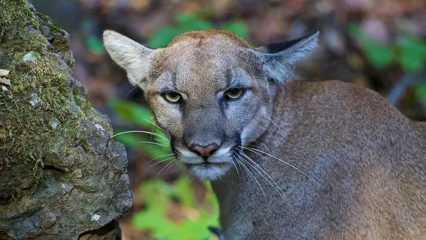
Cougar Death Highlights Urgent Need for Wildlife Crossing
A mountain lion was found dead on the 101 Freeway, less than half a mile from the steel and concrete endoskeleton of the Wallis Annenberg Wildlife Crossing.
USDOT Federal Grant Program Will Fund Wildlife Crossings
The funding will support projects that reduce the risk of vehicle-wildlife collisions and improve habitat connectivity.

National Parks Layoffs Will Cause Communities to Lose Billions
Thousands of essential park workers were laid off this week, just before the busy spring break season.

Retro-silient?: America’s First “Eco-burb,” The Woodlands Turns 50
A master-planned community north of Houston offers lessons on green infrastructure and resilient design, but falls short of its founder’s lofty affordability and walkability goals.

Delivering for America Plan Will Downgrade Mail Service in at Least 49.5 Percent of Zip Codes
Republican and Democrat lawmakers criticize the plan for its disproportionate negative impact on rural communities.

Test News Post 1
This is a summary

Test News Headline 46
Test for the image on the front page.

Balancing Bombs and Butterflies: How the National Guard Protects a Rare Species
The National Guard at Fort Indiantown Gap uses GIS technology and land management strategies to balance military training with conservation efforts, ensuring the survival of the rare eastern regal fritillary butterfly.
Urban Design for Planners 1: Software Tools
This six-course series explores essential urban design concepts using open source software and equips planners with the tools they need to participate fully in the urban design process.
Planning for Universal Design
Learn the tools for implementing Universal Design in planning regulations.
EMC Planning Group, Inc.
Planetizen
Planetizen
Mpact (formerly Rail~Volution)
Great Falls Development Authority, Inc.
HUDs Office of Policy Development and Research
NYU Wagner Graduate School of Public Service