


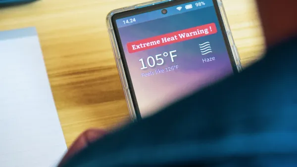
Two federal agencies launched a new, easy-to-use, color-coded heat warning system that combines meteorological and medical risk factors.

The National Weather Service and Centers for Disease Control and Prevention launched a new online heat risk system called the Heat Risk Dashboard, according to an Associated Press article in the Portland Press Herald. The new tool provides a simplified seven-day forecast that uses a color-coded rating system to indicate when temperatures could be a health risk.
Moving forward, magenta will signal the deadliest of the five heat threat categories, indicating rare, long-duration extreme heat with little to no overnight relief, while red will indicate temperatures that fall within the top 5 percent hottest for a specific date and location. Then comes orange (moderate risk), yellow (minor risk, mostly to the very young, old, sick, and pregnant), and green (little to no risk).
The move to a new rating system comes as extreme heat events become more frequent and intense because of climate change. According to a CDC press release, more than two-thirds of Americans were under heat alerts in 2023, and rates of emergency department visits for heat-related illness reached peak levels across several U.S. regions compared to previous years.
The tool was designed to be simple and easy for the public and medical practitioners to use. It could also be a valuable tool for local planners and other city departments when preparing for extreme heat events, which present a major public health threat that disproportionately impacts vulnerable populations and low-income communities, and communicating emergency response plans to community members.
FULL STORY: When red-hot isn’t enough: New government heat risk tool sets magenta as most dangerous level

Experts Call for Extreme Heat Action Plans as Communities Face Growing Risks
Experts are urging cities and counties to develop heat action plans and personalized heat warnings as extreme heat becomes a leading cause of climate-related deaths.

HUD Issues Extreme Heat Playbook
The guide contains actionable steps local and state governments can take to protect vulnerable residents from the impacts of extreme heat.

Study: Heat Deaths on the Rise, Predicted to Increase
As intense heat waves become more common, the risk of heat-related deaths is rising.

National Parks Layoffs Will Cause Communities to Lose Billions
Thousands of essential park workers were laid off this week, just before the busy spring break season.

Retro-silient?: America’s First “Eco-burb,” The Woodlands Turns 50
A master-planned community north of Houston offers lessons on green infrastructure and resilient design, but falls short of its founder’s lofty affordability and walkability goals.

Delivering for America Plan Will Downgrade Mail Service in at Least 49.5 Percent of Zip Codes
Republican and Democrat lawmakers criticize the plan for its disproportionate negative impact on rural communities.

Test News Post 1
This is a summary

Test News Headline 46
Test for the image on the front page.

Balancing Bombs and Butterflies: How the National Guard Protects a Rare Species
The National Guard at Fort Indiantown Gap uses GIS technology and land management strategies to balance military training with conservation efforts, ensuring the survival of the rare eastern regal fritillary butterfly.
Urban Design for Planners 1: Software Tools
This six-course series explores essential urban design concepts using open source software and equips planners with the tools they need to participate fully in the urban design process.
Planning for Universal Design
Learn the tools for implementing Universal Design in planning regulations.
EMC Planning Group, Inc.
Planetizen
Planetizen
Mpact (formerly Rail~Volution)
Great Falls Development Authority, Inc.
HUDs Office of Policy Development and Research
NYU Wagner Graduate School of Public Service