


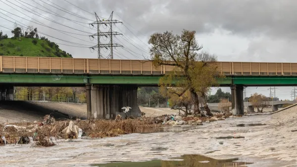
During this “super year” of storms, L.A. County has successfully captured 96 billion gallons of stormwater which is enough to meet the needs of about 2.4 million people a year.
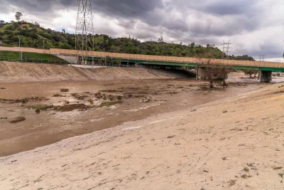
Los Angeles County has managed to capture and store a significant amount of stormwater brought forth by heavy rains this winter and spring which sent torrential flows down local creeks and rivers. Specifically, an estimated 295,000 acre-feet of water since last October or 96.3 billion gallons was captured. This is sufficient to meet the water needs of approximately 2.4 million people a year, which is almost one-fourth of the county’s population of ten million residents.
As reported by Ian James, the county, working in coordination and collaboration with the Los Angeles Department of Water and Power and other agencies, was able to capture and store this amount of water thanks in part to investments totaling over $1 billion since 2001. Some of the funding has been used to raise dams and increase the capacity of spreading grounds, where water is sent into basins and then percolates underground into aquifers.
The county has also spent more than $1 billion since 2001 to remove sediment from reservoirs to ensure their water-catching capacity is not limited or diminished. A large portion of the funds have come from the L.A. County Flood Control District, which receives revenues through property taxes. Funding for stormwater-catching infrastructure is also generated through the Safe, Clean Water Program, which was established after county voters passed Measure W in 2018.
Though the amount of runoff captured since October has been substantial, the county’s facilities took in more water during the major storms over the previous 12 months — an estimated 626,000 acre-feet, which is enough to supply about five million residents for a year.
To learn more, please read the source article.
FULL STORY: L.A. County captures 96 billion gallons of water during ‘super year’ of storms

Downpours Yield 33 Billion Gallons of Captured Stormwater in L.A. County
County officials hope reclamation efforts will help the region reduce its dependence on imported water supplies.

California's Stormwater Potential
A new study reveals that if California could collect and treat more stormwater in cities, it could provide enough water to supply a quarter of the state’s urban population.
How Capturing Rainwater Can Make Cities Safer, More Resilient
Green infrastructure can help prevent flooding and replenish groundwater supplies, preventing subsidence that makes land sink.

National Parks Layoffs Will Cause Communities to Lose Billions
Thousands of essential park workers were laid off this week, just before the busy spring break season.

Retro-silient?: America’s First “Eco-burb,” The Woodlands Turns 50
A master-planned community north of Houston offers lessons on green infrastructure and resilient design, but falls short of its founder’s lofty affordability and walkability goals.

Delivering for America Plan Will Downgrade Mail Service in at Least 49.5 Percent of Zip Codes
Republican and Democrat lawmakers criticize the plan for its disproportionate negative impact on rural communities.

Test News Post 1
This is a summary

Test News Headline 46
Test for the image on the front page.

Balancing Bombs and Butterflies: How the National Guard Protects a Rare Species
The National Guard at Fort Indiantown Gap uses GIS technology and land management strategies to balance military training with conservation efforts, ensuring the survival of the rare eastern regal fritillary butterfly.
Urban Design for Planners 1: Software Tools
This six-course series explores essential urban design concepts using open source software and equips planners with the tools they need to participate fully in the urban design process.
Planning for Universal Design
Learn the tools for implementing Universal Design in planning regulations.
EMC Planning Group, Inc.
Planetizen
Planetizen
Mpact (formerly Rail~Volution)
Great Falls Development Authority, Inc.
HUDs Office of Policy Development and Research
NYU Wagner Graduate School of Public Service