


An explainer of the monetary, environmental, and social costs of exuberant road building.
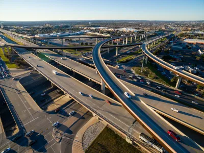
Reporting for KERA, Nathan Bernier outlines how the Texas Department of Transportation (TxDOT), which spends more on highways than any other state, funds its road projects. In the last ten years alone, Texas added 700 miles of new highways.
As Bernier explains, “The money for highways comes from a mix of gas taxes, vehicle registration fees, state sales taxes, levies on oil and gas companies and federal funds — which includes a big chunk of money from personal income taxes.” Historically, highways have been funded via a consumer gas tax that goes into the federal Highway Trust Fund. Now, federal dollars make up a smaller percentage of state’s road funding, and the Highway Trust Fund routinely runs out of money. “The federal gas tax — now 18.4 cents a gallon — hasn’t risen since President Bill Clinton's first year in office. The Texas gas tax is even older, frozen at 20 cents a gallon since 1991.”
Texas voters supported additional highway funding through several measures, letting the state dip into its Rainy Day Fund and allocating part of the state sales tax to road projects.
However, it’s not just about construction costs. “The true cost also includes external factors like traffic congestion, displacement, environmental impacts, and land use changes, all of which affect local communities.” Additionally, highways encourage sprawling suburbs and inefficient land use and prioritize driving over transit and other forms of transportation.
FULL STORY: Who pays for Texas highways?

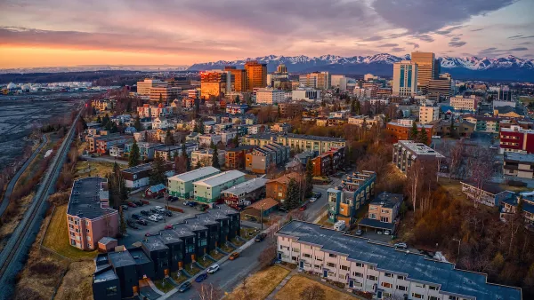
Anchorage High-Speed Highway Project Met With Skepticism
The Alaska Department of Transportation and its consultants are working on a Planning and Environmental Linkages study of the Glenn-Seward Highway that bisects the middle of Anchorage, Alaska.
Proposal Would Link Highway Funding to Zoning
Experts argue that zoning, housing, and transportation policy are intimately linked.
‘Divided by Design’ Underscores Inequities in Transportation Policy
The report calls for a wholesale overhaul of U.S. transportation policy to redress the damages caused by decades of auto-centric development.

National Parks Layoffs Will Cause Communities to Lose Billions
Thousands of essential park workers were laid off this week, just before the busy spring break season.

Retro-silient?: America’s First “Eco-burb,” The Woodlands Turns 50
A master-planned community north of Houston offers lessons on green infrastructure and resilient design, but falls short of its founder’s lofty affordability and walkability goals.

Delivering for America Plan Will Downgrade Mail Service in at Least 49.5 Percent of Zip Codes
Republican and Democrat lawmakers criticize the plan for its disproportionate negative impact on rural communities.

Test News Post 1
This is a summary

Test News Headline 46
Test for the image on the front page.

Balancing Bombs and Butterflies: How the National Guard Protects a Rare Species
The National Guard at Fort Indiantown Gap uses GIS technology and land management strategies to balance military training with conservation efforts, ensuring the survival of the rare eastern regal fritillary butterfly.
Urban Design for Planners 1: Software Tools
This six-course series explores essential urban design concepts using open source software and equips planners with the tools they need to participate fully in the urban design process.
Planning for Universal Design
Learn the tools for implementing Universal Design in planning regulations.
EMC Planning Group, Inc.
Planetizen
Planetizen
Mpact (formerly Rail~Volution)
Great Falls Development Authority, Inc.
HUDs Office of Policy Development and Research
NYU Wagner Graduate School of Public Service