


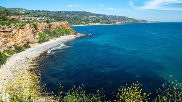
The city of Palos Verdes is closing parts of a roadway to cyclists, citing safety concerns as the land underneath moves between 7 and 12 inches per week.

Coastal erosion is causing dangerous driving conditions on a Southern California road, prompting the Rancho Palos Verdes City Council to issue a ban on two-wheeled vehicles on the roadway. “Land movement is happening at a rate of 7 to 12 inches per week on Palos Verdes Drive South, according to the city,” reports Michael Hixon in Daily Breeze.
The city’s Public Works Director defended the move, saying, “Sometimes, fissures, dips, bumps, other pavement irregularities are forming, and although four-wheeled vehicles can usually navigate these, given the warning signs and slowing down, the same cannot be said for two-wheeled vehicles.”
The two-mile stretch of road in question includes Lloyd Wright, Jr.’s iconic Wayfarers Chapel, which is being dismantled and relocated to more solid ground. “In March, city officials warned Palos Verdes Drive South, where approximately 16,000 cars travel daily, might have to be closed to all traffic while workers performed the regrading or built a detour route.”
Local bike advocates are urging the city to take other safety measures while allowing bicyclists to continue to use the road. “Cars swerving to avoid fissures is just as dangerous, said commenters, as motorcyclists or bicyclists on the road.”
FULL STORY: Land movement forces Rancho Palos Verdes to prohibit motorcycles and bicycles on main road

Southern California City Offers Buyout to Homeowners Facing Erosion Threat
Power and gas were shut off to dozens of homes in Rancho Palos Verdes as landslides threatened homes and infrastructure. Now, the city is offering to buy the homes to help residents relocate.

Rising Above: Innovative Solutions for Waikīkī’s Sea-Level Challenges
The University of Hawaiʻi at Mānoa’s award-winning Waikīkī sea-level rise adaptation project combines science, architecture, and community input to create scalable solutions for climate resilience and coastal flood mitigation.

Preparing for Climate Migration
Billions of people will have to relocate in the next decades. Are governments prepared?

National Parks Layoffs Will Cause Communities to Lose Billions
Thousands of essential park workers were laid off this week, just before the busy spring break season.

Retro-silient?: America’s First “Eco-burb,” The Woodlands Turns 50
A master-planned community north of Houston offers lessons on green infrastructure and resilient design, but falls short of its founder’s lofty affordability and walkability goals.

Delivering for America Plan Will Downgrade Mail Service in at Least 49.5 Percent of Zip Codes
Republican and Democrat lawmakers criticize the plan for its disproportionate negative impact on rural communities.

Test News Post 1
This is a summary

Test News Headline 46
Test for the image on the front page.

Balancing Bombs and Butterflies: How the National Guard Protects a Rare Species
The National Guard at Fort Indiantown Gap uses GIS technology and land management strategies to balance military training with conservation efforts, ensuring the survival of the rare eastern regal fritillary butterfly.
Urban Design for Planners 1: Software Tools
This six-course series explores essential urban design concepts using open source software and equips planners with the tools they need to participate fully in the urban design process.
Planning for Universal Design
Learn the tools for implementing Universal Design in planning regulations.
EMC Planning Group, Inc.
Planetizen
Planetizen
Mpact (formerly Rail~Volution)
Great Falls Development Authority, Inc.
HUDs Office of Policy Development and Research
NYU Wagner Graduate School of Public Service