


New York City created a Google Maps layer to help residents and tourists alike more easily locate public restrooms.
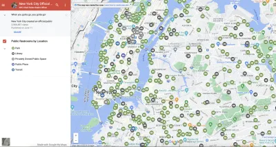
Accessibility of public restrooms is an often overlooked yet critical aspect of the urban experience. Because if there is one universal truth, it is, “When you gotta go you gotta go.” According to a recent Bloomberg CityLab article, New York City recently acknowledged that truth when it built and released a Google Map layer that shows the city’s nearly 1,000 public toilets.
The new map, which Bloomberg reporter Sarah Holder reports was viewed 2.5 million times in the first few weeks of its launch, shows the location and operating hours of free restroom facilities in parks, plazas, libraries, and transit centers across the city. It is part of a broader city initiative called “Ur In Luck” to increase accessibility to public toilets, which also aims to create 46 new and renovate 36 existing park restrooms over the next five years. The plan includes an additional 14 self-cleaning public toilets as well.
Access to restrooms is one of humans’ most basic needs, which begs the question: Can a city be truly livable without it? With its current initiative, New York City seems to have acknowledged their importance. Will NYC serve as a role model for the many other U.S. cities that lack adequate restroom facilities?
FULL STORY: The Quest for a Public Bathroom in New York City

Meet NYC’s New Office of Livable Streets
The NYC DOT program will build on pandemic-era initiatives to promote safe and comfortable streets that enhance community and expand uses beyond just moving cars.
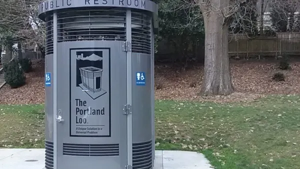
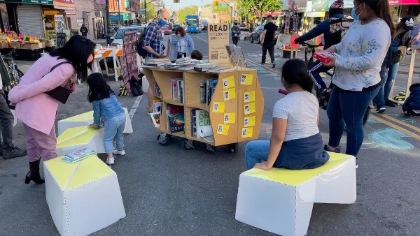
New York City Parks Getting Modular Public Bathrooms
The ‘Portland Loo,’ named after its birth city, is designed to withstand year-round weather and resist vandalism.
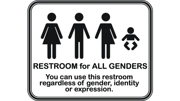
Sometimes Gender Neutral Bathrooms Have Nothing to Do With Gender Identity
There are several reasons that gender neutral bathrooms will soon replace separated men's and women's bathrooms, and they have nothing to do with gender identity, explains Jimmy Parker, event producer and former BID director.

National Parks Layoffs Will Cause Communities to Lose Billions
Thousands of essential park workers were laid off this week, just before the busy spring break season.

Retro-silient?: America’s First “Eco-burb,” The Woodlands Turns 50
A master-planned community north of Houston offers lessons on green infrastructure and resilient design, but falls short of its founder’s lofty affordability and walkability goals.

Delivering for America Plan Will Downgrade Mail Service in at Least 49.5 Percent of Zip Codes
Republican and Democrat lawmakers criticize the plan for its disproportionate negative impact on rural communities.

Test News Post 1
This is a summary

Test News Headline 46
Test for the image on the front page.

Balancing Bombs and Butterflies: How the National Guard Protects a Rare Species
The National Guard at Fort Indiantown Gap uses GIS technology and land management strategies to balance military training with conservation efforts, ensuring the survival of the rare eastern regal fritillary butterfly.
Urban Design for Planners 1: Software Tools
This six-course series explores essential urban design concepts using open source software and equips planners with the tools they need to participate fully in the urban design process.
Planning for Universal Design
Learn the tools for implementing Universal Design in planning regulations.
EMC Planning Group, Inc.
Planetizen
Planetizen
Mpact (formerly Rail~Volution)
Great Falls Development Authority, Inc.
HUDs Office of Policy Development and Research
NYU Wagner Graduate School of Public Service