


Why roadways that try to serve everyone can be some of the most dangerous.
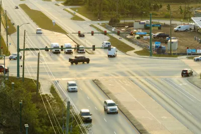
Ever heard of a ‘stroad?’ This hybrid of street and road, a thoroughfare that attempts to serve both drivers and pedestrians, is becoming known among planners and transportation engineers as a ‘worst of both worlds’ approach to road design, explains Liam Davies in a piece for The Conversation.
Stroads have an inherent conflict between their role as a movement corridor and their role as a place. While they try to be everything to everyone, they become nothing to anyone.
Davies describes Australian roads, many of which qualify as stroads and were built decades ago. Now, some Australian states are looking to a ‘movement and place’ framework to identify what role roads should play.
But, Davies writes, “To truly solve the stroad, we need to change the priority of the street. We need to remove some space given to cars (both driving and parking), and give that space to people and place.” Concepts like Complete Streets reimagine roadways with more space for people and public transit, while initiatives like parklets let residents envision alternate uses of public space.
FULL STORY: Not quite a street, not quite a road – why ‘stroads’ are disasters of urban planning, and how to fix them


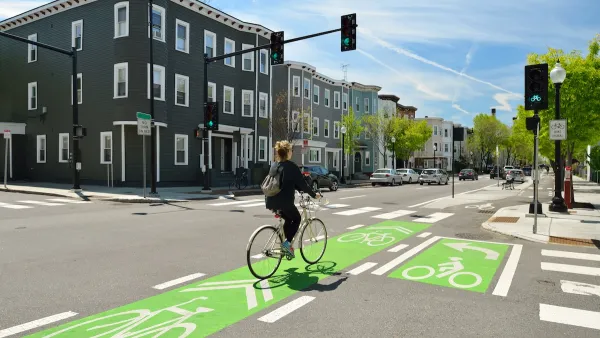
US Street Design Manual Inches Toward Safer Roads
The guiding document for U.S. road design is starting to recognize the needs of people walking and biking, but safe streets advocates say more significant changes are needed to reduce the high number of pedestrian deaths and improve connectivity for all road users.

California Governor Signs Complete Streets Bill Into Law
The state’s transportation agency will be required to prioritize multimodal transportation infrastructure and improve transparency.
NACTO Releases Updated Urban Bikeway Guide
The third edition of the nationally recognized road design guide includes detailed design advice for roads that prioritize safety and accessibility for all users.

National Parks Layoffs Will Cause Communities to Lose Billions
Thousands of essential park workers were laid off this week, just before the busy spring break season.

Retro-silient?: America’s First “Eco-burb,” The Woodlands Turns 50
A master-planned community north of Houston offers lessons on green infrastructure and resilient design, but falls short of its founder’s lofty affordability and walkability goals.

Delivering for America Plan Will Downgrade Mail Service in at Least 49.5 Percent of Zip Codes
Republican and Democrat lawmakers criticize the plan for its disproportionate negative impact on rural communities.

Test News Post 1
This is a summary

Test News Headline 46
Test for the image on the front page.

Balancing Bombs and Butterflies: How the National Guard Protects a Rare Species
The National Guard at Fort Indiantown Gap uses GIS technology and land management strategies to balance military training with conservation efforts, ensuring the survival of the rare eastern regal fritillary butterfly.
Urban Design for Planners 1: Software Tools
This six-course series explores essential urban design concepts using open source software and equips planners with the tools they need to participate fully in the urban design process.
Planning for Universal Design
Learn the tools for implementing Universal Design in planning regulations.
EMC Planning Group, Inc.
Planetizen
Planetizen
Mpact (formerly Rail~Volution)
Great Falls Development Authority, Inc.
HUDs Office of Policy Development and Research
NYU Wagner Graduate School of Public Service