


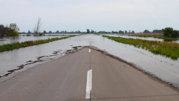
The federal tool used to inform flood protection spending calculates communities' risk by multiplying expected annual loss in dollars by their risk factor. As a result, many rural areas are classified as “low” risk, despite frequent, severe flooding.
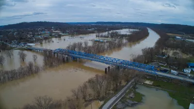
Daily Yonder, in a collaboration with Climate Central, published an article highlighting the “bias” in FEMA’s disaster assistance calculations, which it says could prevent rural regions from benefiting from flood mitigation projects funded by the Bipartisan Infrastructure Bill and future federal infrastructure funding. “FEMA developed its National Risk Index to help local and state officials and residents plan for emergencies through an online tool,” write authors Claire Carlson and Elizabeth Miller. The tool uses historic rainfall and other data to characterize risk and inform its spending decisions. The problem? Many rural communities, even those that have suffered from natural disasters like major flooding in the past, are still classified as “low” risk by the tool, “largely because they have less to lose — financially — compared to more urbanized areas,” according to the article.
The article offers in-depth examples of how this “bias” has played out in Eastern Kentucky, which floods on a regular basis but experienced a catastrophic flooding event two years ago. Despite this fact, FEMA’s National Risk Index classifies the 13 counties declared federal disaster areas two years ago as facing “low” or “very low” risks. That’s because the “National Risk Index multiplies a community’s expected annual loss in dollars by their risk factor,” according to the article, and the median household income and home values in those rural counties is significantly lower, in some cases up to half, of the national average.
“This urban-rural difference matters because FEMA uses the National Risk Index to determine how much money communities should receive to better prepare for natural disasters” the article reads.
Chad Berginnis, executive director of the Association of State Floodplain Managers, also told Daily Yonder and Climate Central: “There’s a bias against, I think, rural communities, especially in the flood dataset,” which he said could “profoundly” confuse or affect emergency managers in those areas. That tool is also “being used to make decisions about spending $1.2 trillion available to lessen future flood risks under the U.S. Infrastructure Investment and Jobs Act,” Carlson and Miller write, which could lead to underinvestment in rural communities.
This is also an important issue in the context of the housing affordability crisis. There is an urgency to build new, affordable housing units, but the cheapest and most readily available land to build on also tends to be the land most vulnerable to flooding and other hazards. Without accurate and unbiased data and risk calculation, there is a potential that a lot of that new housing could end up in areas that are at high-risk for climate-related disasters.
FULL STORY: The Rural Americans Too Poor for Federal Flood Protections

FEMA Extends Deadline for Hazard Mitigation Grant Applications
Tight applications prevented many communities struck by disasters from applying for FEMA resilience grants, so the agency issued a new rule that extended the application window.

Delivering for America Plan Will Downgrade Mail Service in at Least 49.5 Percent of Zip Codes
Republican and Democrat lawmakers criticize the plan for its disproportionate negative impact on rural communities.
The Growing Role of Federal Government in Disaster Relief
As flooding, fires, and other disasters become more destructive, an effective response requires more resources than local governments can offer.

National Parks Layoffs Will Cause Communities to Lose Billions
Thousands of essential park workers were laid off this week, just before the busy spring break season.

Retro-silient?: America’s First “Eco-burb,” The Woodlands Turns 50
A master-planned community north of Houston offers lessons on green infrastructure and resilient design, but falls short of its founder’s lofty affordability and walkability goals.
Delivering for America Plan Will Downgrade Mail Service in at Least 49.5 Percent of Zip Codes
Republican and Democrat lawmakers criticize the plan for its disproportionate negative impact on rural communities.

Test News Post 1
This is a summary

Test News Headline 46
Test for the image on the front page.

Balancing Bombs and Butterflies: How the National Guard Protects a Rare Species
The National Guard at Fort Indiantown Gap uses GIS technology and land management strategies to balance military training with conservation efforts, ensuring the survival of the rare eastern regal fritillary butterfly.
Urban Design for Planners 1: Software Tools
This six-course series explores essential urban design concepts using open source software and equips planners with the tools they need to participate fully in the urban design process.
Planning for Universal Design
Learn the tools for implementing Universal Design in planning regulations.
EMC Planning Group, Inc.
Planetizen
Planetizen
Mpact (formerly Rail~Volution)
Great Falls Development Authority, Inc.
HUDs Office of Policy Development and Research
NYU Wagner Graduate School of Public Service