


The extended tollway would cut beyond the Urban Growth Boundary into the Everglades.
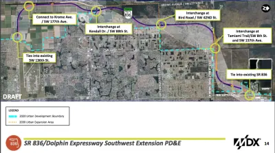
According to Jay Koziarz, "a controversial plan to extend the Dolphin Expressway through the Everglades to West Kendall was OK’d by Miami-Dade commissioners on Thursday by a 9-4 vote."
The project will add 13 miles of tollway on land located beyond the Urban Development Boundary established to protect this corner of the Everglades.
Despite the decision by Miami-Dade commissioners to approve the preliminary plan for the extended expressway, there's still a lot of ground to cover before the project is ready to break ground. Koziarz explains:
Despite winning over the majority of commissioners and appearing to be a forgone conclusion, the project still needs to secure state, federal, and Department of Environmental Resources Management permits. Meanwhile, the county’s new “sexy highway” could potentially face some not-so-sexy lawsuits. Stay tuned.
Another article written by Jenny Staletovich just before the commission's vote digs into the lack of a solid route plan for the project. "In a legal notice published in advance of the hearing last week, the county included a map depicting an eastern route. Commissioners’ application packet, however, contains a map with the route to the west," writes Staletovich. Opponents of the project seized on the lack of detail and transparency as the commission considered the plan.
FULL STORY: Miami-Dade approves Dolphin Expressway extension through the Everglades


California Environmental Leaders Call on State Agencies to Prioritize Multimodal Transportation
Even before President Trump took office, California was not meeting its emissions reduction goals.

Opinion: LA Should Reject ‘Misguided’ Car-Centric Policies
Even as the city highlights clean energy and transportation for the 2028 Olympics, Metro and Caltrans move forward with plans to expand highways.
Florida to Provide Toll Relief for Frequent Commuters
It will be cheaper to drive around Florida, starting January 1.

National Parks Layoffs Will Cause Communities to Lose Billions
Thousands of essential park workers were laid off this week, just before the busy spring break season.

Retro-silient?: America’s First “Eco-burb,” The Woodlands Turns 50
A master-planned community north of Houston offers lessons on green infrastructure and resilient design, but falls short of its founder’s lofty affordability and walkability goals.

Delivering for America Plan Will Downgrade Mail Service in at Least 49.5 Percent of Zip Codes
Republican and Democrat lawmakers criticize the plan for its disproportionate negative impact on rural communities.

Test News Post 1
This is a summary

Test News Headline 46
Test for the image on the front page.

Balancing Bombs and Butterflies: How the National Guard Protects a Rare Species
The National Guard at Fort Indiantown Gap uses GIS technology and land management strategies to balance military training with conservation efforts, ensuring the survival of the rare eastern regal fritillary butterfly.
Urban Design for Planners 1: Software Tools
This six-course series explores essential urban design concepts using open source software and equips planners with the tools they need to participate fully in the urban design process.
Planning for Universal Design
Learn the tools for implementing Universal Design in planning regulations.
EMC Planning Group, Inc.
Planetizen
Planetizen
Mpact (formerly Rail~Volution)
Great Falls Development Authority, Inc.
HUDs Office of Policy Development and Research
NYU Wagner Graduate School of Public Service