


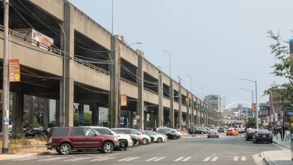
Sections of the Alaskan Way Viaduct will begin closing on January 4, 2019. The city's new tunnel to replace the route doesn't open until February.
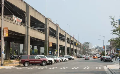
The long-awaited tunnel to replace the Alaskan Way Viaduct will open in February, but not before the Alaskan Way Viaduct closes. Stephen Fesler provides details on the "Seattle Squeeze."
The first impacts from the closure of the SR-99 viaduct will begin on January 4th with the southbound S Atlantic St off-ramp and northbound Royal Brougham Way on-ramp. Other on- and off-ramps as well as the highway mainline will remain open until 10pm on January 11th when the remainder of the viaduct will fully closes.
The Washington State Department of Transportation (WSDOT) expects that the full viaduct closure will send an estimated 90,000 daily vehicle trips to other roads or convert to other types of trips until the new deep-bore tunnel opens in February.
As for what the state and the city will have to do to make up the difference in the meantime, Fesler provides lots of details:
WSDOT is planning to convert I-5 southbound high occupancy vehicle (HOV) lanes to general purpose lanes from Mercer Street to S Corson St just for good measure–keeping motorists happy and suffering in equal measure while ensuring transit is exceptionally slow on I-5.
Moreover:
The Seattle Department of Transportation (SDOT) will roll out temporary transit lanes on Cherry Street, 4th Ave S, Aurora Avenue, and the West Seattle Bridge ahead of the viaduct closure.
Fesler notes that some of these changes could become permanent, like the measures taken in New York City to address the L Train closure. An earlier Planetizen post by Philip Rojc offers more insight and background on the Seattle Squeeze.
FULL STORY: Extra Water Taxi Service and a Few Temporary Bus Lanes Planned for Seattle Squeeze

New Marketing Campaign: Pushing People to Drive More in Seattle
Now that Seattle has proven they don't need the new Highway 99 tunnel that will replace the Alaskan Way Viaduct, will enough people use it in the future to cover the costs of construction, operation, and maintenance?
Seattle Scrambles to Handle Upcoming Traffic 'Squeeze'
Dubbed the "Seattle Squeeze," heavier traffic is expected in the new year as the Alaskan Way Viaduct closes and downtown construction projects continue. While the city prepares, activists want to use the opportunity to encourage other modes.
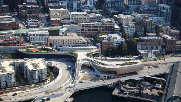
Seattle’s New Overlook Walk Offers Ample Park Space Near Pike Place Market
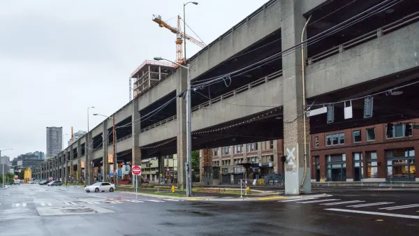
The elevated park and event space replaces part of the demolished Alaskan Way Viaduct, connecting the city’s famous Pike Place Market to the waterfront.

National Parks Layoffs Will Cause Communities to Lose Billions
Thousands of essential park workers were laid off this week, just before the busy spring break season.

Retro-silient?: America’s First “Eco-burb,” The Woodlands Turns 50
A master-planned community north of Houston offers lessons on green infrastructure and resilient design, but falls short of its founder’s lofty affordability and walkability goals.

Delivering for America Plan Will Downgrade Mail Service in at Least 49.5 Percent of Zip Codes
Republican and Democrat lawmakers criticize the plan for its disproportionate negative impact on rural communities.

Test News Post 1
This is a summary

Test News Headline 46
Test for the image on the front page.

Balancing Bombs and Butterflies: How the National Guard Protects a Rare Species
The National Guard at Fort Indiantown Gap uses GIS technology and land management strategies to balance military training with conservation efforts, ensuring the survival of the rare eastern regal fritillary butterfly.
Urban Design for Planners 1: Software Tools
This six-course series explores essential urban design concepts using open source software and equips planners with the tools they need to participate fully in the urban design process.
Planning for Universal Design
Learn the tools for implementing Universal Design in planning regulations.
EMC Planning Group, Inc.
Planetizen
Planetizen
Mpact (formerly Rail~Volution)
Great Falls Development Authority, Inc.
HUDs Office of Policy Development and Research
NYU Wagner Graduate School of Public Service