


Erick Guerra of the University of Pennsylvania writes about a recent article he co-authored in the Journal of Planning Education and Research

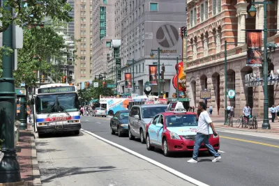
Traffic collisions are one of the leading causes of death, physical injury, and property damages in the United States. Although more than ten people out of 100,000 die in traffic collisions each year, fatality and collision rates vary substantially by state, city, and neighborhood. The safest state, New York, had just 5.0 fatalities per hundred thousand residents in 2017. Mississippi had 23.1. Substantial variation in settlement patterns across cities and states may help to explain some of the variation in traffic safety records.
In a recent article in the Journal of Planning Education & Research, we explore the relationship between population density and traffic safety in the Philadelphia region, controlling for other measures of built form. At first glance, densely populated states, counties, and cities have better traffic records than more sparsely populated ones. However, the empirical literature is mixed. Of the studies we reviewed for this paper, 14 found statistically significant positive correlations between population density and traffic collision or collision severity, nine found statistically significant inverse correlations, and three studies presented mixed results. Still others dropped population density due to statistical insignificance. A better understanding of whether denser neighborhoods correlate with higher or lower traffic fatalities could shed light on the likely public health effects of promoting compact cities and help households make more informed decisions about the tradeoffs between different types of neighborhoods.
After matching crashes, injuries, and fatalities to street segments and intersections, we estimate models of total crashes, pedestrian-involved crashes, serious injuries, pedestrian serious injuries, fatalities, and pedestrian fatalities. For each outcome, we include a series of control variables that population density likely influences but are also associated with traffic safety, such as neighborhood socio-demographics, total vehicle travel, total pedestrian exposure, street design, and posted speed limits. Thus, we considered the relationship between population density and traffic collisions, independent of and dependent on a fixed level of exposure, existing road networks, and other land use patterns and socio-demographic characteristics.
In the Philadelphia region, we find that denser neighborhoods have fewer crashes and substantially safer roads than less densely populated ones. Roads in denser neighborhoods also generally have fewer traffic fatalities, with and without controls for road type, road length, speed limit, exposure, and urban form. The amount and type of roadway appear particularly important. Across our sample and including controls for vehicle travel, 300 feet of 45 mph arterial had ten times more expected fatalities than 150 feet of local roadway with a 25 mph speed limit.
Findings were more mixed for pedestrian injuries, which tend to increase with population density in the suburbs, but decrease with population density in the city. Our findings suggest that policies allowing increased densities, particularly in the suburbs, may require greater attention to pedestrian safety. Reducing the quantity, speed, and size of suburban roadways would likely help.
Our study provides support that denser neighborhoods offer safer streets in the Philadelphia region. But the relationship between density and pedestrian safety is mixed. The amount and type of roadway is particularly important. At least in the long run, the biggest safety difference between compact cities and sprawling ones may simply be that compact cities tend to have less roadway and less driving.
Advocating for compact neighborhoods design has been a hallmark of progressive planning for decades now, with most advocates toting their smaller environmental footprint. To this, our study in Philadelphia suggests another important benefit: they may help prevent crashes and reduce their severity, saving lives.
Full Article Open Access Until July 11th, 2019
Dr. Erick Guerra is an assistant professor in the Department of City and Regional Planning at the University of Pennsylvania.

Has Progress on Travel Safety Run Off the Road?
Changing technology and rebuilding infrastructure to improve road safety are long-term strategies. How can enforcement and interventions that influence driver behavior make a difference in reducing traffic deaths sooner?

Making Autonomous Vehicles Safer for Blind Pedestrians
A team of researchers is developing a dataset to fill a critical gap in self-driving cars’ learning models.
Heavier Vehicles Don’t Keep Passengers Safer
A new study shows that modern safety features are more important than size and weight once vehicles weigh over 4,000 pounds.

Analysis: Cybertruck Fatality Rate Far Exceeds That of Ford Pinto
The Tesla Cybertruck was recalled seven times last year.

National Parks Layoffs Will Cause Communities to Lose Billions
Thousands of essential park workers were laid off this week, just before the busy spring break season.

Retro-silient?: America’s First “Eco-burb,” The Woodlands Turns 50
A master-planned community north of Houston offers lessons on green infrastructure and resilient design, but falls short of its founder’s lofty affordability and walkability goals.

Test News Post 1
This is a summary

Analysis: Cybertruck Fatality Rate Far Exceeds That of Ford Pinto
The Tesla Cybertruck was recalled seven times last year.

Test News Headline 46
Test for the image on the front page.
Urban Design for Planners 1: Software Tools
This six-course series explores essential urban design concepts using open source software and equips planners with the tools they need to participate fully in the urban design process.
Planning for Universal Design
Learn the tools for implementing Universal Design in planning regulations.
EMC Planning Group, Inc.
Planetizen
Planetizen
Mpact (formerly Rail~Volution)
Great Falls Development Authority, Inc.
HUDs Office of Policy Development and Research
NYU Wagner Graduate School of Public Service