


Google Maps is built for able-bodied people, but the AccessMap Seattle app is for everyone.
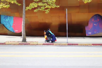
Megan Wildhood shares news of a website and mobile app called AccessMap Seattle, where "users can find streets color-coded for steepness (green for flat, yellow for moderate, and red for steep), and the locations of curb cuts, bus stops, and elevators, as well as construction sites, which tend to sprawl and block crosswalks and sidewalks."
Nick Bolten, developer of AccessMap Seattle, is now partnering with Anat Caspi, director of The Taskar Center for Accessible Technology at the University of Washington, to further develop the app, especially in identifying different mobility challenges facing people with special needs. And there plenty of complications in the world:
The diversity of disability also complicates data collection: A map of sidewalks, curb cuts, or steepness of streets might not be sufficient for those with limited mobility. For example, are there major cracks in the sidewalk because of disrepair, tree roots, or other damage? Does the sidewalk slope at an angle dangerous to wheelchair users? To source such varying data, the AccessMap team is considering GPS navigation app Waze as a model.
The app is still in development, but some users are already testing the app. "Eventually, the team hopes, it could benefit those with mobility limitations who navigate Seattle, especially those without knowledge of the city’s lesser-known accessible routes. And it could also benefit the larger public by producing data to drive forward discussions of access and ability," writes Wildhood.
FULL STORY: How Steep Is That Sidewalk? A Digital Map for People With Disabilities


'Project Sidewalk' Crowdsources ADA Compliance
A crowdsourcing app allows citizens to hold the public realm to higher standards of access and mobility.
America’s 15 Most Accessible Cities
These cities are the easiest to navigate for people in wheelchairs or with mobility challenges.
New Guidelines Bring Clarity to Accessibility Requirements
The new rules could help bridge the gaps in accessibility infrastructure and ADA compliance, making roads and sidewalks safer for everyone.

Analysis: Cybertruck Fatality Rate Far Exceeds That of Ford Pinto
The Tesla Cybertruck was recalled seven times last year.

National Parks Layoffs Will Cause Communities to Lose Billions
Thousands of essential park workers were laid off this week, just before the busy spring break season.

Retro-silient?: America’s First “Eco-burb,” The Woodlands Turns 50
A master-planned community north of Houston offers lessons on green infrastructure and resilient design, but falls short of its founder’s lofty affordability and walkability goals.

Test News Post 1
This is a summary

Analysis: Cybertruck Fatality Rate Far Exceeds That of Ford Pinto
The Tesla Cybertruck was recalled seven times last year.

Test News Headline 46
Test for the image on the front page.
Urban Design for Planners 1: Software Tools
This six-course series explores essential urban design concepts using open source software and equips planners with the tools they need to participate fully in the urban design process.
Planning for Universal Design
Learn the tools for implementing Universal Design in planning regulations.
EMC Planning Group, Inc.
Planetizen
Planetizen
Mpact (formerly Rail~Volution)
Great Falls Development Authority, Inc.
HUDs Office of Policy Development and Research
NYU Wagner Graduate School of Public Service