


A new satellite, currently residing on the International Space Station and scheduled for deployment in January, will measure and map the urban heat island effect of seven U.S. cities.

Arizona State University students built a satellite named CubeSat that launched this month into space on an Antares rocket.
Ian James reports on the recent launch of the satellite, known as CubeSat, which measures only 12 inches long by 4 inches wide and weighed 8.6 pounds. Cubesat was engineered to capture block-by-block, infrared images of Phoenix and six other U.S. cities. The resulting data on heat trends "could help urban planners design cooler cityscapes to withstand the effects as the world continues to heat up due to the burning of fossil fuels," according to the article.
"Four years ago, the students wrote a proposal to build the satellite and obtained $200,000 in NASA funding," explains James of how the project came to be. "A total of about 80 undergraduate students took part in the project. Many of them spent long hours designing the spacecraft, piecing together the components, testing its systems, and writing code to make it all work."
"In addition to focusing on Phoenix, the plan is for the satellite to gather thermal images of Los Angeles, Chicago, Houston, Atlanta, Baltimore and Minneapolis," adds James, who also provides details of how the new data will be used to create new forms of climate mapping for the cities under study.
FULL STORY: Satellite built by students soars to space on mission to map heat in Phoenix, other cities

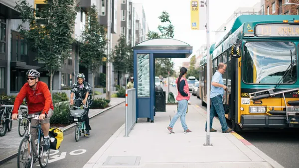
As Heat Waves Become More Common, Bus Shelters Are Needed to Keep Transit Riders Onboard
As climate change brings prolonged, intense heat waves to cities once associated with rain and cold weather will have to attend to the lack of shelter provided to bus and transit riders.

Key Climate and Health Issues to Watch in 2025
The escalating health impacts of climate change, from extreme heat to sea level rise, highlight the urgent need for integrated medical education, proactive communication, and sustainable policy solutions to protect public health.

Phoenix Announces Shade Action Plan
The city has outlined 11 strategic priorities aimed at addressing the risks of extreme heat and protecting vulnerable residents from its impacts.

Analysis: Cybertruck Fatality Rate Far Exceeds That of Ford Pinto
The Tesla Cybertruck was recalled seven times last year.

National Parks Layoffs Will Cause Communities to Lose Billions
Thousands of essential park workers were laid off this week, just before the busy spring break season.

Retro-silient?: America’s First “Eco-burb,” The Woodlands Turns 50
A master-planned community north of Houston offers lessons on green infrastructure and resilient design, but falls short of its founder’s lofty affordability and walkability goals.

Test News Post 1
This is a summary

Analysis: Cybertruck Fatality Rate Far Exceeds That of Ford Pinto
The Tesla Cybertruck was recalled seven times last year.

Test News Headline 46
Test for the image on the front page.
Urban Design for Planners 1: Software Tools
This six-course series explores essential urban design concepts using open source software and equips planners with the tools they need to participate fully in the urban design process.
Planning for Universal Design
Learn the tools for implementing Universal Design in planning regulations.
EMC Planning Group, Inc.
Planetizen
Planetizen
Mpact (formerly Rail~Volution)
Great Falls Development Authority, Inc.
HUDs Office of Policy Development and Research
NYU Wagner Graduate School of Public Service