


Using a wagon filled with phones, an artist in Berlin demonstrated the disconnect between data and the real world.
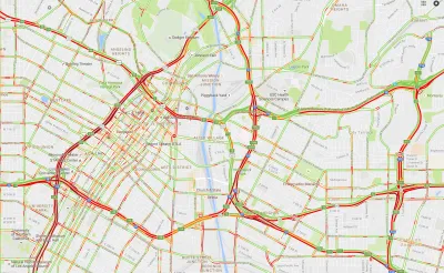
Simon Weckert is an artist who traversed the street of Berlin pulling a wagon filled with 99 smartphones connected to Google Maps. The result was a series of maps showing illusory traffic jams and congestion on roads, some of which were empty.
"The maps are their own territory, their own objective reality, not just a reflection of the real world but a branch of it. Weckert was showing us all how data and maps can affect the world they’re meant to chart," writes Matthew Gault.
In addition, data itself is not objective and Weckert’s hacking demonstrates how it can be warped and manipulated, says Gault. According to Weckert, both collecting and analyzing data are activities open to interpretation.
FULL STORY: This Man Created Traffic Jams on Google Maps Using a Red Wagon Full of Phones


The Gig Economy for Mapping
A new startup wants to use blockchain and the Uber model to create free, open-source maps.

The Growing Importance of Location Intelligence
Location intelligence is transforming decision-making, with an increasing number and type of organizations modernizing operations with a geographic approach to problem-solving, planning, and prediction.

Debunking the Myth of the Declining White Population
Media claimed that Census data showed a sharp decline in America's white population, but the widely publicized figure reflects a misunderstanding of new data collection techniques.

National Parks Layoffs Will Cause Communities to Lose Billions
Thousands of essential park workers were laid off this week, just before the busy spring break season.

Retro-silient?: America’s First “Eco-burb,” The Woodlands Turns 50
A master-planned community north of Houston offers lessons on green infrastructure and resilient design, but falls short of its founder’s lofty affordability and walkability goals.

Delivering for America Plan Will Downgrade Mail Service in at Least 49.5 Percent of Zip Codes
Republican and Democrat lawmakers criticize the plan for its disproportionate negative impact on rural communities.

Test News Post 1
This is a summary

Test News Headline 46
Test for the image on the front page.

Balancing Bombs and Butterflies: How the National Guard Protects a Rare Species
The National Guard at Fort Indiantown Gap uses GIS technology and land management strategies to balance military training with conservation efforts, ensuring the survival of the rare eastern regal fritillary butterfly.
Urban Design for Planners 1: Software Tools
This six-course series explores essential urban design concepts using open source software and equips planners with the tools they need to participate fully in the urban design process.
Planning for Universal Design
Learn the tools for implementing Universal Design in planning regulations.
EMC Planning Group, Inc.
Planetizen
Planetizen
Mpact (formerly Rail~Volution)
Great Falls Development Authority, Inc.
HUDs Office of Policy Development and Research
NYU Wagner Graduate School of Public Service