


The Metropolitan Atlanta Rapid Transit Authority recently proposed ambitious station design concepts to supplement the Georgia Department of Transportation's plans for a 16-mile express bus lane system on Ga. Highway 400.
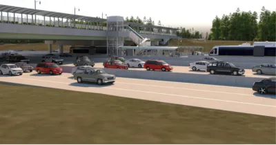
The Metropolitan Atlanta Rapid Transit Authority (MARTA) has revealed new station concepts for proposed express bus lanes on Ga. Highway 400 that would add five stops between Sandy Springs and Alpharetta.
Josh Green reports on the newly released station concepts for the project, cautioning that the bus station concepts still have a long way to go, and funding uncertainties to overcome, before coming to fruition.
"In a perfect world for MARTA," however, "the Georgia Department of Transportation’s express lanes project on Ga. Highway 400 will open in about six years with efficient bus stops in the middle of highway lanes, dotted from Sandy Springs to the northern reaches of Alpharetta, offering transportation alternatives to thousands of commuters daily."
The bus station concepts are meant to supplement the work done by the Georgia Department of Transportation on the express lanes project. As Green explains, "MARTA’s broader goal is to take advantage of the billion-dollar investment GDOT is making to build about 16 miles of express lanes up Ga. Highway 400 as part of the agency’s Major Mobility Investment Program, which will also see express lanes installed on Interstate 285."
In all, "MARTA hopes to build five BRT stations, with stops at North Springs, Holcomb Bridge Road, North Point Mall, Old Milton Parkway, and Windward Parkway in Alpharetta, near Cumming. Total costs could exceed $176 million." MARTA is suggesting that a tax allocation district (TAD) or a special services district (the latter gaining a new example on the BeltLine earlier this month) to come up with the necessary funding to build the stations.
FULL STORY: Concepts emerge for MARTA's rapid bus system up Ga. Highway 400

Atlanta Transit Officials Call for Traffic Cameras to Enforce Bus-Only Lanes
MARTA says bus-mounted cameras would be a more effective way to keep bus lanes clear and make upcoming bus rapid transit lines run smoothly and reliably.
BRT Stations Cut, Project Delayed in Atlanta
Inflation is taking a bite out of planned transportation projects in Georgia. The state's first ever bus rapid transit project provides the latest example of scaled back ambitions.
Light Rail Plans Could Become Bus Rapid Transit Plans in Atlanta
Light rail on the Clifton Corridor was once a centerpiece of a $2.7 billion, 40-year transit expansion plans funded by a voter-approved sales tax. Now MARTA is considering using bus rapid transit on the corridor instead.

National Parks Layoffs Will Cause Communities to Lose Billions
Thousands of essential park workers were laid off this week, just before the busy spring break season.

Retro-silient?: America’s First “Eco-burb,” The Woodlands Turns 50
A master-planned community north of Houston offers lessons on green infrastructure and resilient design, but falls short of its founder’s lofty affordability and walkability goals.

Delivering for America Plan Will Downgrade Mail Service in at Least 49.5 Percent of Zip Codes
Republican and Democrat lawmakers criticize the plan for its disproportionate negative impact on rural communities.

Test News Post 1
This is a summary

Test News Headline 46
Test for the image on the front page.

Balancing Bombs and Butterflies: How the National Guard Protects a Rare Species
The National Guard at Fort Indiantown Gap uses GIS technology and land management strategies to balance military training with conservation efforts, ensuring the survival of the rare eastern regal fritillary butterfly.
Urban Design for Planners 1: Software Tools
This six-course series explores essential urban design concepts using open source software and equips planners with the tools they need to participate fully in the urban design process.
Planning for Universal Design
Learn the tools for implementing Universal Design in planning regulations.
EMC Planning Group, Inc.
Planetizen
Planetizen
Mpact (formerly Rail~Volution)
Great Falls Development Authority, Inc.
HUDs Office of Policy Development and Research
NYU Wagner Graduate School of Public Service