


The walkway is simpler and faster to build than a sidewalk, letting the city quickly and cost-effectively improve pedestrian safety on important walking corridors.
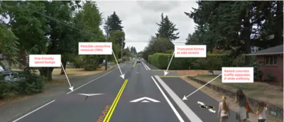
The city of Portland is experimenting with a new type of pedestrian walkway that could "improve walking conditions without the expense or complication of building a full-fledged sidewalk." Jonathan Maus of Bike Portland reports on the "alternative pedestrian walkway," a one-mile pilot project on Portland's Northeast 60th Avenue.
"Identified as a major walking corridor in the city’s pedestrian master plan (Ped PDX, 2019), 60th was like many streets in Cully and other less-developed parts of Portland: it had two general lanes and no space for shoulders, bike lanes or sidewalks. To get the space for a six-foot wide walkway on one side of the street, PBOT shifted the centerline over about four feet. They then leveled and paved the existing gravel shoulder." The walkway is marked with pedestrian markings and crossings feature "zebra-striping, truncated domes (those tiny yellow bumps), and a few plastic delineator wands."
Although not designed as a bikeway, use by bicycles is allowed. "Until PBOT establishes good bikeways nearby, this could become a useful bikeway." The project provides a template for quick, low-cost pedestrian improvements.
FULL STORY: First Look: Portland’s novel ‘alternative pedestrian walkway’


Portland Transportation Bureau Faces ‘Existential’ Cuts
PBOT’s director says the agency’s impending budget shortfall could imperil even basic transportation and infrastructure services.

Audit: Portland’s Vision Zero Needs More Data, Funding
A city audit found that the program has failed to reduce traffic deaths and could benefit from a more systematic approach. Meanwhile, PBOT says it needs more state funding to support road safety projects.

Southeast LA Road Safety Advocates Call for Improved Infrastructure
Streets in southeastern Los Angeles County have a severe lack of protected bike lanes and traffic safety measures, leading to high numbers of fatalities in a community where many residents depend on walking and biking for daily needs.

National Parks Layoffs Will Cause Communities to Lose Billions
Thousands of essential park workers were laid off this week, just before the busy spring break season.

Retro-silient?: America’s First “Eco-burb,” The Woodlands Turns 50
A master-planned community north of Houston offers lessons on green infrastructure and resilient design, but falls short of its founder’s lofty affordability and walkability goals.

Delivering for America Plan Will Downgrade Mail Service in at Least 49.5 Percent of Zip Codes
Republican and Democrat lawmakers criticize the plan for its disproportionate negative impact on rural communities.

Test News Post 1
This is a summary

Test News Headline 46
Test for the image on the front page.

Balancing Bombs and Butterflies: How the National Guard Protects a Rare Species
The National Guard at Fort Indiantown Gap uses GIS technology and land management strategies to balance military training with conservation efforts, ensuring the survival of the rare eastern regal fritillary butterfly.
Urban Design for Planners 1: Software Tools
This six-course series explores essential urban design concepts using open source software and equips planners with the tools they need to participate fully in the urban design process.
Planning for Universal Design
Learn the tools for implementing Universal Design in planning regulations.
EMC Planning Group, Inc.
Planetizen
Planetizen
Mpact (formerly Rail~Volution)
Great Falls Development Authority, Inc.
HUDs Office of Policy Development and Research
NYU Wagner Graduate School of Public Service