


Although some cities are in favor of removing or reducing urban freeways in favor of more walkable spaces, guidelines like the 11-year-old MUTCD still encourage a 'throughput at all costs' mentality.
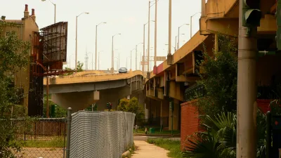
As the movement to remove urban freeways and reconnect neighborhoods gains strength, writes Scott Beyer, Northern Virginia's National Landing provides a sample of the conflict between freeway removal advocates and the state and federal programs that perpetuate freeway building and expansion. "The local business improvement district (BID) wants to convert U.S. Route 1, an elevated highway that divides National Landing’s downtown, into a walkable boulevard with narrower lanes and slower car speeds." But state officials want to keep the road at its current width, citing concerns "that narrowing Route 1 would divert too much traffic to local roads."
In Boston, mobility advocates are calling for "an at-grade reconstruction that is less disruptive than the elevated highway" of the city's Interstate 90 viaduct, but are facing similar opposition from the state's department of transportation, which, according to reports, "may even make the elevated viaduct taller and wider."
The conflict stems in part from the seldom-updated, federal Manual on Uniform Traffic Control Devices (MUTCD), whose guidelines "dictate lane widths, shoulder widths and curve radii, and are written with automobile speed in mind." Because "[h]ighway engineers tend to use a 'level of service' (LOS) metric to determine whether a road has adequate capacity," typical designs focus on prioritizing vehicle speed with little regard to pedestrian or cyclist safety or convenience.
With local residents and businesses on board with less car-centric retrofits of urban freeways, it's time that state and federal DOTs understand "it may be unwise for them to force this 'throughput at all costs' vision onto the urban parts of state and federal routes" when cities are realizing the "tremendous economic and cultural value that is diminished" by reducing roads to simply corridors for moving traffic as efficiently as possible.
FULL STORY: Will States and the Feds Let Cities Tame Urban Highways?


US Street Design Manual Inches Toward Safer Roads
The guiding document for U.S. road design is starting to recognize the needs of people walking and biking, but safe streets advocates say more significant changes are needed to reduce the high number of pedestrian deaths and improve connectivity for all road users.
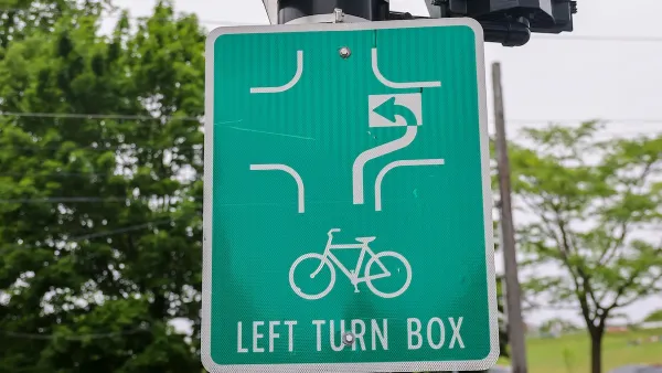
US Road Design Manual Gets Multimodal Update
The long-awaited changes include road design elements and signage aimed at improving safety for pedestrians and cyclists while planning for autonomous vehicles.
Reforms Are Coming to American Road Design
The federal manual governing road design is getting an update. Will it encourage real progress toward road safety?

National Parks Layoffs Will Cause Communities to Lose Billions
Thousands of essential park workers were laid off this week, just before the busy spring break season.

Retro-silient?: America’s First “Eco-burb,” The Woodlands Turns 50
A master-planned community north of Houston offers lessons on green infrastructure and resilient design, but falls short of its founder’s lofty affordability and walkability goals.

Delivering for America Plan Will Downgrade Mail Service in at Least 49.5 Percent of Zip Codes
Republican and Democrat lawmakers criticize the plan for its disproportionate negative impact on rural communities.

Test News Post 1
This is a summary

Test News Headline 46
Test for the image on the front page.

Balancing Bombs and Butterflies: How the National Guard Protects a Rare Species
The National Guard at Fort Indiantown Gap uses GIS technology and land management strategies to balance military training with conservation efforts, ensuring the survival of the rare eastern regal fritillary butterfly.
Urban Design for Planners 1: Software Tools
This six-course series explores essential urban design concepts using open source software and equips planners with the tools they need to participate fully in the urban design process.
Planning for Universal Design
Learn the tools for implementing Universal Design in planning regulations.
EMC Planning Group, Inc.
Planetizen
Planetizen
Mpact (formerly Rail~Volution)
Great Falls Development Authority, Inc.
HUDs Office of Policy Development and Research
NYU Wagner Graduate School of Public Service