


The New York Department of City Planning has taken its open data practices to a new level with the launch of the Capital Planning Explorer.

The New Your City Department of City Planning (DCP) last week launched the Capital Planning Explorer, a new, map-based website aimed at increasing transparency around capital planning, according to a DCP press release. The Capital Planning Explorer website describes the new tool as "a place for the public and planners to access the maps and data that they need to better plan for investments in neighborhoods and collaborate with one another."
The map offers three layers: Capital Projects, Facilities, and New Housing Developments. The Housing Development maps, for example, include all housing permits in all five boroughs, color-coded by new construction, building alterations, or demolitions. "This supplemental information on the number and types of housing units found on any city block is key to the city’s planning processes for capital projects," according to the website.
According to the Capital Planning Explorer website, the tool uses derived from the Capital Commitment Plan published by the city's Office of Management and Budget (OMB), in addition to supporting data from Checkbook NYC, a resource provided by the comptroller, and spatial data from but not limited to data created and published by DDC, DPR,ORR, and DCP. All datasets are available for download.
The press release included soundbites from DCP Director Anita Laremont, who touts the new tool as emblematic of work by the DCP to build more trust and transparency.
FULL STORY: A NEW DIGITAL TOOL FOR THE PUBLIC: DCP Launches Capital Planning Explorer

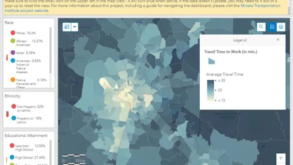
Smart Growth Loves Heatmaps
Smart growth can provide many important benefits that are easy to see using informative and beautiful heatmaps—our complex world as viewed by all-knowing gods.
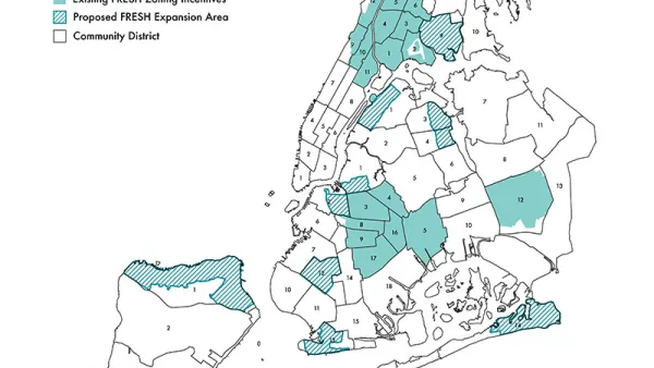
Zoning Incentives for Supermarkets: New York Expands its FRESH Program
The FRESH program, previously offering zoning incentives for grocery store development in 19 districts around New York City, will expand to 11 new locations.

Lawsuit Challenges Zoom Hearings on Gowanus Rezoning Plan
Planning departments relying on online public hearing processes will want to keep monitor this lawsuit in New York City.

Analysis: Cybertruck Fatality Rate Far Exceeds That of Ford Pinto
The Tesla Cybertruck was recalled seven times last year.

National Parks Layoffs Will Cause Communities to Lose Billions
Thousands of essential park workers were laid off this week, just before the busy spring break season.

Retro-silient?: America’s First “Eco-burb,” The Woodlands Turns 50
A master-planned community north of Houston offers lessons on green infrastructure and resilient design, but falls short of its founder’s lofty affordability and walkability goals.

Test News Post 1
This is a summary

Analysis: Cybertruck Fatality Rate Far Exceeds That of Ford Pinto
The Tesla Cybertruck was recalled seven times last year.

Test News Headline 46
Test for the image on the front page.
Urban Design for Planners 1: Software Tools
This six-course series explores essential urban design concepts using open source software and equips planners with the tools they need to participate fully in the urban design process.
Planning for Universal Design
Learn the tools for implementing Universal Design in planning regulations.
EMC Planning Group, Inc.
Planetizen
Planetizen
Mpact (formerly Rail~Volution)
Great Falls Development Authority, Inc.
HUDs Office of Policy Development and Research
NYU Wagner Graduate School of Public Service