


The online tool now shows granular, tree-level data that highlights the public health benefits and economic contributions of urban trees.
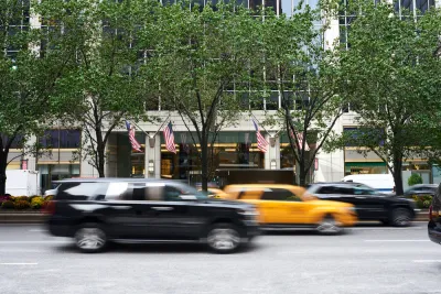
New York City’s tree map just received a makeover, adding fine-grained data that can help New Yorkers understand the specific environmental, social, and economic impacts of street trees from the individual tree to the neighborhood scale.
As Linda Poon explains in Bloomberg CityLab, “The New York City Tree Map, launched Thursday, is an expansion of the city’s existing street tree map, which since 2016 has enabled New Yorkers to get up close and personal with the 650,000-some trees that line their neighborhood sidewalks.” The tool “pulls up stats on its ecological and financial contribution to the city, as calculated using formulas from the US Forest Service. Zoom out, and the map calculates all the benefits at a neighborhood level.”
“By drumming up public appreciation for the city’s greenery, the city hopes to encourage more people to help care for trees in their parks and neighborhoods. Volunteers can log any care they provide to a tree, whether that’s watering it, removing garbage from the tree bed, or pruning branches (which requires citizens to first obtain a permit).”
Additionally, “New Yorkers can also alert officials to any specific tree in need of attention by digitally tagging it on the map on their phone and putting in a service request or reporting an issue.”
FULL STORY: New York City’s Popular Online Tree Map Gets a Big Update


Urban Trees Have Bigger Impact in Hot, Dry Cities
The cooling effect of robust urban tree canopies is more pronounced in hotter, drier cities like Phoenix and Las Vegas.
The Economic Value of Street Trees
Far from just providing shade and improving air quality, trees can also contribute to more resilient roads, lower energy costs, and reduced flood risk.
Tree Folio NYC Aims to Monitor Urban Forest in Real Time
A new tool could help the city reach its goal of planting up to 250,000 new trees by 2035.

Analysis: Cybertruck Fatality Rate Far Exceeds That of Ford Pinto
The Tesla Cybertruck was recalled seven times last year.

National Parks Layoffs Will Cause Communities to Lose Billions
Thousands of essential park workers were laid off this week, just before the busy spring break season.

Retro-silient?: America’s First “Eco-burb,” The Woodlands Turns 50
A master-planned community north of Houston offers lessons on green infrastructure and resilient design, but falls short of its founder’s lofty affordability and walkability goals.

Test News Post 1
This is a summary

Analysis: Cybertruck Fatality Rate Far Exceeds That of Ford Pinto
The Tesla Cybertruck was recalled seven times last year.

Test News Headline 46
Test for the image on the front page.
Urban Design for Planners 1: Software Tools
This six-course series explores essential urban design concepts using open source software and equips planners with the tools they need to participate fully in the urban design process.
Planning for Universal Design
Learn the tools for implementing Universal Design in planning regulations.
EMC Planning Group, Inc.
Planetizen
Planetizen
Mpact (formerly Rail~Volution)
Great Falls Development Authority, Inc.
HUDs Office of Policy Development and Research
NYU Wagner Graduate School of Public Service