


Norwalk, Connecticut is figuring out how to balance the competing interests of development demand, public access, environmental risks, and historic preservation.
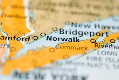
Norwalk, located in Fairfield County, Connecticut, is working on a new waterfront plan that balances the community’s long history and the contemporary risks of sea-level rise and climate change.
According to an article by Katherine Lutge, the city has been planning the future of the waterfront since 2021. Boston-based firm UTILE Architecture & Planning produced the "Norwalk Industrial Waterfront Land Use Study" earlier this year, and now several local organizations are concerned about zoning and other changes proposed by the report.
According to the city, the three primary goals of the plan are to increase public access to the waterfront, retain commercial and industrial water dependent uses, and address environmental concerns through development best practices.
“By proposing zoning that allows for mixed-use development that is water dependent, there is an opportunity to redevelop the sites closest to Washington Street, which may activate the waterfront area for public access. This could potentially include restaurants, boardwalks, boat slips and public open space,” according to a statement from the city quoted in the article.
Lutge also reports, however, that the Harbor Management Commission, Shellfish Commission, and Water Quality Commission are raising concerns about the possibility of new development density on the city’s waterfront, potentially in the 100-year floodplain.
More details about the proposed zoning changes, and the emerging opposition to those changes, are included in the source article below.
FULL STORY: Norwalk debates history, density and future of waterfront due to new plan, zoning rewrite


‘Grand Boulevards’ Could Ease Housing Crisis
A prominent urbanist argues that redeveloping commercial corridors with denser housing could bridge the gap between the housing supply and demand.

Boston Moves Zoning Reform Forward
The ‘Squares + Streets’ plan creates form-based zoning templates for neighborhoods that promote mixed use and denser housing near transit.
How Transit Villages Are Reshaping New Jersey’s Urban Landscape
Will the Garden State become Manhattan 2.0 in the next 50 years? Probably not. Will it look different from today? Probably yes.

National Parks Layoffs Will Cause Communities to Lose Billions
Thousands of essential park workers were laid off this week, just before the busy spring break season.

Retro-silient?: America’s First “Eco-burb,” The Woodlands Turns 50
A master-planned community north of Houston offers lessons on green infrastructure and resilient design, but falls short of its founder’s lofty affordability and walkability goals.

Delivering for America Plan Will Downgrade Mail Service in at Least 49.5 Percent of Zip Codes
Republican and Democrat lawmakers criticize the plan for its disproportionate negative impact on rural communities.

Test News Post 1
This is a summary

Test News Headline 46
Test for the image on the front page.

Balancing Bombs and Butterflies: How the National Guard Protects a Rare Species
The National Guard at Fort Indiantown Gap uses GIS technology and land management strategies to balance military training with conservation efforts, ensuring the survival of the rare eastern regal fritillary butterfly.
Urban Design for Planners 1: Software Tools
This six-course series explores essential urban design concepts using open source software and equips planners with the tools they need to participate fully in the urban design process.
Planning for Universal Design
Learn the tools for implementing Universal Design in planning regulations.
EMC Planning Group, Inc.
Planetizen
Planetizen
Mpact (formerly Rail~Volution)
Great Falls Development Authority, Inc.
HUDs Office of Policy Development and Research
NYU Wagner Graduate School of Public Service