


Most vehicles will be barred from entering a 5.5 square kilometer zone to limit traffic, noise, and pollution.

Paris will begin limiting car traffic in the city’s central core, according to an article in Le Monde, per a decree issued by Mayor Anne Hidalgo, who has for years championed a more walkable, bikeable Paris, and co-signed by the city’s police department. “The decree applies to the first, second, third and fourth districts in the capital, an area of some 5.5 square kilometers that includes landmarks such as the Louvre Museum and Tuileries Gardens.”
Vehicle access will be restricted to “emergency vehicles, buses, taxis, people with reduced mobility, motorists living or working there and so-called ‘destination traffic’ including those in the area for a specific reason such as a medical appointment, shopping, or cinema visit.”
The limited traffic zone (ZTL) is expected to lead to as much as a 30 percent decrease in traffic on the busiest roads. “The system will be enforced via a system of proof of residence and online declarations, with an initial grace period as people get used to the new rules, the city hall said.”
FULL STORY: Paris set to limit traffic in the city's central core

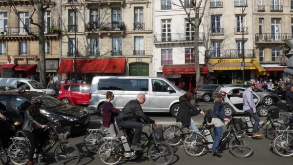
Paris To Ban Most Cars in 'Quiet Zone'
Continuing Mayor Anne Hidalgo's efforts to make Paris more accessible to pedestrians and cyclists, the city plans to implement a 'car-light' zone in the city center that prohibits through traffic.
How Walkable ‘Activity Centers’ Can Reduce Driving
Encouraging mixed-use neighborhoods that help reduce vehicle miles driven and put urban amenities within easy walking distance is possible with surprisingly modest policy tweaks.

L.A. Approves ‘Park Block’ Program
Inspired by Barcelona’s superblocks, the program aims to limit car traffic in small areas to improve safety and create new park spaces.

National Parks Layoffs Will Cause Communities to Lose Billions
Thousands of essential park workers were laid off this week, just before the busy spring break season.

Retro-silient?: America’s First “Eco-burb,” The Woodlands Turns 50
A master-planned community north of Houston offers lessons on green infrastructure and resilient design, but falls short of its founder’s lofty affordability and walkability goals.

Delivering for America Plan Will Downgrade Mail Service in at Least 49.5 Percent of Zip Codes
Republican and Democrat lawmakers criticize the plan for its disproportionate negative impact on rural communities.

Test News Post 1
This is a summary

Test News Headline 46
Test for the image on the front page.

Balancing Bombs and Butterflies: How the National Guard Protects a Rare Species
The National Guard at Fort Indiantown Gap uses GIS technology and land management strategies to balance military training with conservation efforts, ensuring the survival of the rare eastern regal fritillary butterfly.
Urban Design for Planners 1: Software Tools
This six-course series explores essential urban design concepts using open source software and equips planners with the tools they need to participate fully in the urban design process.
Planning for Universal Design
Learn the tools for implementing Universal Design in planning regulations.
EMC Planning Group, Inc.
Planetizen
Planetizen
Mpact (formerly Rail~Volution)
Great Falls Development Authority, Inc.
HUDs Office of Policy Development and Research
NYU Wagner Graduate School of Public Service