


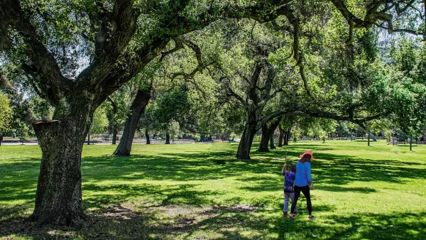
Annapolis has launched an interactive Tree Canopy Map to engage residents in urban forestry efforts, highlighting tree coverage data and encouraging community involvement to achieve the city’s 50 percent canopy goal by 2050.

The City of Annapolis has introduced a new interactive Tree Canopy Map, aiming to engage residents in enhancing and sustaining the city's urban forest. This publicly accessible tool provides detailed information on individual street trees, including species, size, and environmental contributions such as carbon sequestration and stormwater reduction. By exploring the map, users can identify areas with sparse tree coverage and contribute to strategic planting efforts.
Developed in collaboration with PlanIT Geo, a leader in urban forestry software and consulting, the Tree Canopy Map allows residents to compare canopy coverage across different neighborhoods. This feature helps pinpoint regions that would benefit from additional tree planting, supporting the city's goal of achieving a 50 percent tree canopy by 2050. Currently, Annapolis stands at approximately 42 percent coverage, highlighting the need for community involvement to reach this target.
City officials emphasize the importance of public participation, noting that much of the available space for new trees is on residential properties. Urban Forester Brian Adams stated, "We need the public’s help to meet our tree canopy goals." Residents are encouraged to utilize the Tree Canopy Map to assess their neighborhoods and consider planting suitable trees, thereby contributing to a healthier and more resilient urban environment.
FULL STORY: Annapolis Launches Interactive Tree Canopy Map to Support Urban Forestry Efforts

Branching Out: Building Health and Equity Through Community Forestry
Los Angeles County’s Community Forest Management Plan seeks to create a healthier, more equitable community forest by expanding tree coverage, engaging communities, and building resilience to climate impacts.

Addressing Tree Canopy Disparity in South Los Angeles
A new study highlights the complex challenge of addressing tree canopy disparities in South L.A., where historical environmental injustices, budget constraints, and competing community priorities hinder efforts to increase equitable tree coverage.

LA County Releases Draft Community Forest Management Plan
LA County's Chief Sustainability Office just released the discussion draft of Room to Grow, the first Community Forest Management Plan for the county.

Analysis: Cybertruck Fatality Rate Far Exceeds That of Ford Pinto
The Tesla Cybertruck was recalled seven times last year.

National Parks Layoffs Will Cause Communities to Lose Billions
Thousands of essential park workers were laid off this week, just before the busy spring break season.

Retro-silient?: America’s First “Eco-burb,” The Woodlands Turns 50
A master-planned community north of Houston offers lessons on green infrastructure and resilient design, but falls short of its founder’s lofty affordability and walkability goals.

Test News Post 1
This is a summary

Analysis: Cybertruck Fatality Rate Far Exceeds That of Ford Pinto
The Tesla Cybertruck was recalled seven times last year.

Test News Headline 46
Test for the image on the front page.
Urban Design for Planners 1: Software Tools
This six-course series explores essential urban design concepts using open source software and equips planners with the tools they need to participate fully in the urban design process.
Planning for Universal Design
Learn the tools for implementing Universal Design in planning regulations.
EMC Planning Group, Inc.
Planetizen
Planetizen
Mpact (formerly Rail~Volution)
Great Falls Development Authority, Inc.
HUDs Office of Policy Development and Research
NYU Wagner Graduate School of Public Service