


Officials in Miami-Dade County have just released their parks master plan, an ambitious proposal that looks to go beyond creating park space by redefining the region's public realm.
"Miami-Dade County on Friday will roll out an extraordinarily ambitious parks and open-space master plan that aims over the next half-century to re-green and reconnect a community that has spent much of the previous 50 years carving up and paving over the natural landscape."
"'This is probably the single most important thing that Miami-Dade Parks and Recreation has been involved in in decades,' said county parks director Jack Kardys. 'It really is about leaving a legacy for the community.'"
"The plan, approved last month by the County Commission, reaches well beyond traditional park concepts to what planners call 'the public realm' -- laying out new principles to guide not only how the county plans parks and public places, but also how it builds and designs streets and sidewalks to encourage more people to walk and bicycle. It calls for what amounts to a massive makeover of Miami-Dade's asphalt look and, planners hope, its increasingly congested quality of life."
"Among its most ambitious elements: a 40-mile-plus bikeable loop connecting Biscayne and Everglades national parks along Southwest 328th and 344th streets at the southern end of the county, and a vast north-to-south recreational and ecological zone along the eastern edge of the Everglades, most of it on land already under public control."
FULL STORY: Dade rolling out massive parks plan

Best Ideas of the Week
We all know there's a lot of planning going on around the world. Much of it is poor, short-sighted and generally just no good. But there are also some really great ideas being developed and adopted, and they should be considered by cities and communities all over the world as instructive examples of good planning. Here are what I think are some of the best ideas in urban planning from the last week.
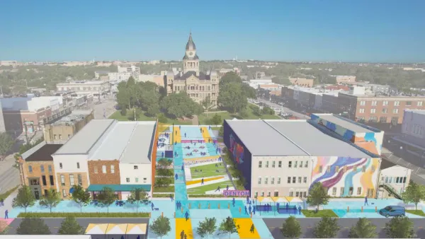
North Texas Town Launches Downtown Revitalization Plan
The Design Downtown Denton plan takes aim at improving walkability and highlighting the city’s historic assets.

Oklahoma House Approves Protections for Drivers Who Hit Protestors
A heated debate and a party line vote in Oklahoma.

National Parks Layoffs Will Cause Communities to Lose Billions
Thousands of essential park workers were laid off this week, just before the busy spring break season.

Retro-silient?: America’s First “Eco-burb,” The Woodlands Turns 50
A master-planned community north of Houston offers lessons on green infrastructure and resilient design, but falls short of its founder’s lofty affordability and walkability goals.

Delivering for America Plan Will Downgrade Mail Service in at Least 49.5 Percent of Zip Codes
Republican and Democrat lawmakers criticize the plan for its disproportionate negative impact on rural communities.

Test News Post 1
This is a summary

Test News Headline 46
Test for the image on the front page.

Balancing Bombs and Butterflies: How the National Guard Protects a Rare Species
The National Guard at Fort Indiantown Gap uses GIS technology and land management strategies to balance military training with conservation efforts, ensuring the survival of the rare eastern regal fritillary butterfly.
Urban Design for Planners 1: Software Tools
This six-course series explores essential urban design concepts using open source software and equips planners with the tools they need to participate fully in the urban design process.
Planning for Universal Design
Learn the tools for implementing Universal Design in planning regulations.
EMC Planning Group, Inc.
Planetizen
Planetizen
Mpact (formerly Rail~Volution)
Great Falls Development Authority, Inc.
HUDs Office of Policy Development and Research
NYU Wagner Graduate School of Public Service