


New modeling software could soon be available that would allow monitoring across the internet of flood levels in specific areas- like your backyard.
"The images are all too familiar: overtopped levees, homes submerged in floodwaters, rescuers motoring down city streets in fishing boats. This summer, before the muck had even been cleared from neighborhoods in the heart of the Midwest, the question resurfaced: What happened? Three years after Hurricane Katrina, and 15 years after disastrous flooding throughout the Midwest, how could the country allow rising waters to kill at least 24 people and cause billions in damage to structures and crops? And the Mississippi Basin isn't the only region at risk. Aging flood walls protect areas from California's Sacramento–San Joaquin River Delta to the shores of Florida's Lake Okeechobee, threatening future devastation. For many, the answer seems clear. Raise levees high enough to ensure that no flood ever wreaks havoc again.
Unfortunately, it's not so simple. For one thing, it's unclear just how high levees should be built. "In Cedar Rapids [Iowa], nobody would have dreamed the river could get that high," says Jeffrey Schott, an instructor of urban and regional planning at the University of Iowa in Iowa City, where 21 buildings were flooded. The flood walls in Cedar Rapids, which had been built to a so-called 100-year standard, were overwhelmed by water that rose to a 500-year level. (The language is misleading: The next "500-year flood" could come next spring.)
'After '93, we could have built the levees in the Midwest 10 ft. higher, for example,' says Robert Holmes, national flood specialist for the United States Geological Survey. 'But the cost far exceeds the benefit.'"
FULL STORY: Thinking Beyond Levees, Experts Turn to New Flood Software

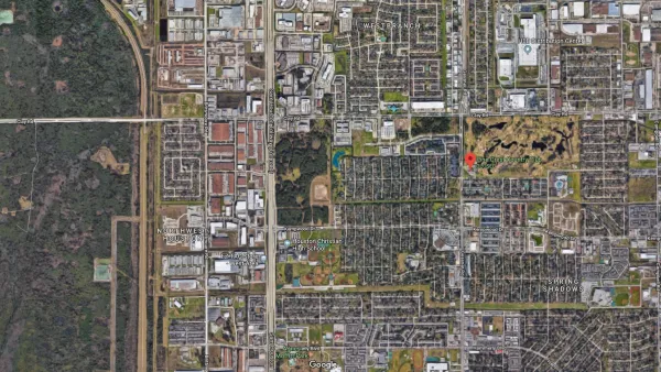
800 New Homes Approved for Houston's Floodplain
The city of Houston approved a new development that doesn't meet new elevations standards approved by the city of Houston earlier this month.
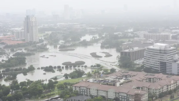
Houston Seriously Tightens Rules on Floodplain Construction
It was the city's "first major regulatory response" to Hurricane Harvey.
Flood Control Project On Death Bed
An Army Corps of Engineers flood control project in south-central Mississippi is in danger of being vetoed by the U.S. Environmental Protection Agency. But supporters have not given up hope.

Analysis: Cybertruck Fatality Rate Far Exceeds That of Ford Pinto
The Tesla Cybertruck was recalled seven times last year.

National Parks Layoffs Will Cause Communities to Lose Billions
Thousands of essential park workers were laid off this week, just before the busy spring break season.

Retro-silient?: America’s First “Eco-burb,” The Woodlands Turns 50
A master-planned community north of Houston offers lessons on green infrastructure and resilient design, but falls short of its founder’s lofty affordability and walkability goals.

Test News Post 1
This is a summary

Analysis: Cybertruck Fatality Rate Far Exceeds That of Ford Pinto
The Tesla Cybertruck was recalled seven times last year.

Test News Headline 46
Test for the image on the front page.
Urban Design for Planners 1: Software Tools
This six-course series explores essential urban design concepts using open source software and equips planners with the tools they need to participate fully in the urban design process.
Planning for Universal Design
Learn the tools for implementing Universal Design in planning regulations.
EMC Planning Group, Inc.
Planetizen
Planetizen
Mpact (formerly Rail~Volution)
Great Falls Development Authority, Inc.
HUDs Office of Policy Development and Research
NYU Wagner Graduate School of Public Service