


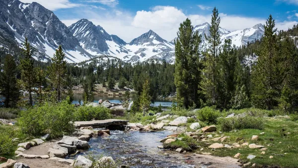
Development has been creeping closer and closer to Palo Duro Canyon in Texas, the country's second biggest canyon. But despite a recent sale of nearby land to developers, preservationists have secured the deed to prevent sprawl from moving in.
"Palo Duro is 120 miles long and 8 miles wide. It lays claim as the second largest canyon in the country after the Grand Canyon. The canyon and river sustain a habitat that would have little chance on the open plains."
"Big horn sheep, mule and white tail deer, coyotes, bobcats and even a mountain lion recently took up residence."
"But what if instead of juniper and mesquite trees along the of canyon rim, there were hundreds of luxury homes with swimming pools, BMWs, gas grills, wrought iron fences and a championship golf course?"
"For the last 20 years, development south of Amarillo, Texas, has slowly been pushing toward the park."
"Last year, the owner of one large ranch that abuts the canyon decided to sell his 3,000 acres to developers. Six miles of canyon rim overlooking the heart of Palo Duro Canyon would have been transformed into a high-end suburb. The park's charm - its feeling of exquisite isolation - would have been lost forever."
FULL STORY: Texas Canyon Escapes Suburban Sprawl


National Parks Layoffs Will Cause Communities to Lose Billions
Thousands of essential park workers were laid off this week, just before the busy spring break season.

Shifts in Shopping: Transforming Malls Into Parks
Maybe zombie malls still have a second life — one with a little greenery.
California Approves $10 Billion Bond for Water, Clean Energy, and Environmental Projects
Funds will be used to support water, wildfire prevention, environmental, and park projects, reflecting strong public support for climate resilience.
National Parks Layoffs Will Cause Communities to Lose Billions
Thousands of essential park workers were laid off this week, just before the busy spring break season.

Retro-silient?: America’s First “Eco-burb,” The Woodlands Turns 50
A master-planned community north of Houston offers lessons on green infrastructure and resilient design, but falls short of its founder’s lofty affordability and walkability goals.

Delivering for America Plan Will Downgrade Mail Service in at Least 49.5 Percent of Zip Codes
Republican and Democrat lawmakers criticize the plan for its disproportionate negative impact on rural communities.

Test News Post 1
This is a summary

Test News Headline 46
Test for the image on the front page.

Balancing Bombs and Butterflies: How the National Guard Protects a Rare Species
The National Guard at Fort Indiantown Gap uses GIS technology and land management strategies to balance military training with conservation efforts, ensuring the survival of the rare eastern regal fritillary butterfly.
Urban Design for Planners 1: Software Tools
This six-course series explores essential urban design concepts using open source software and equips planners with the tools they need to participate fully in the urban design process.
Planning for Universal Design
Learn the tools for implementing Universal Design in planning regulations.
EMC Planning Group, Inc.
Planetizen
Planetizen
Mpact (formerly Rail~Volution)
Great Falls Development Authority, Inc.
HUDs Office of Policy Development and Research
NYU Wagner Graduate School of Public Service