


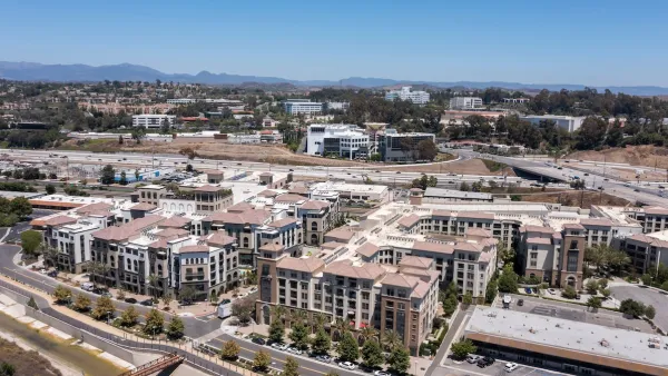
Mesa, AZ is adding a new land use category to its general plan to promote mixed-use, high-density development along the light-rail corridor- specifically in an area of West Mesa formerly dominated by WalMart.
"Giselle Walker pointed toward a desolate parking lot with rows of empty spaces that once were filled with Wal-Mart shoppers. Ever since the store closed, that part of the Mesa strip mall near Main Street and Longmore looks like it could do with some 'life,' said Walker, a longtime Mesa resident, as she piled up her black Chevy Tahoe with groceries from a Fry's east of the lot.
'Life' is what's being planned for that and other parts of west Mesa close to the light rail, which opens for service Dec. 27. City officials are weaving a legal framework to help create an urban environment in this older side of Mesa.
Urban as in shops on the first floor, homes on the second, third and more. Less parking sprawl, more walkable spaces close to Main Street. A community where people can walk to a coffee shop or the dry cleaners from their home, buy groceries, or pick up some flowers and hop on the light rail to get to Tempe or Phoenix and back.
At least that's the hope."
FULL STORY: Mesa strives for Main Street 'renaissance'

Balancing TOD and Public Health
Building housing near transportation networks can improve density and walkability, but can also have serious health consequences for residents.

Expanding the Concept of Transit-Oriented Development: Lessons from Abroad
Keeping transit planning and development siloed can limit opportunities to build affordable housing and vibrant neighborhoods.
Second Massachusetts Town Spurns State TOD Zoning Mandate
Marshfield residents voted down a rezoning plan that would have met state requirements for the town to allow development of multifamily housing near MBTA stations.

National Parks Layoffs Will Cause Communities to Lose Billions
Thousands of essential park workers were laid off this week, just before the busy spring break season.

Retro-silient?: America’s First “Eco-burb,” The Woodlands Turns 50
A master-planned community north of Houston offers lessons on green infrastructure and resilient design, but falls short of its founder’s lofty affordability and walkability goals.

Delivering for America Plan Will Downgrade Mail Service in at Least 49.5 Percent of Zip Codes
Republican and Democrat lawmakers criticize the plan for its disproportionate negative impact on rural communities.

Test News Post 1
This is a summary

Test News Headline 46
Test for the image on the front page.

Balancing Bombs and Butterflies: How the National Guard Protects a Rare Species
The National Guard at Fort Indiantown Gap uses GIS technology and land management strategies to balance military training with conservation efforts, ensuring the survival of the rare eastern regal fritillary butterfly.
Urban Design for Planners 1: Software Tools
This six-course series explores essential urban design concepts using open source software and equips planners with the tools they need to participate fully in the urban design process.
Planning for Universal Design
Learn the tools for implementing Universal Design in planning regulations.
EMC Planning Group, Inc.
Planetizen
Planetizen
Mpact (formerly Rail~Volution)
Great Falls Development Authority, Inc.
HUDs Office of Policy Development and Research
NYU Wagner Graduate School of Public Service