


In the new version of Google Earth, you can compare aerial imagery from the past with current development on the site.
While the majority of the imagery is currently US based, with some areas back as far as 1950, London can be viewed from 1999 onwards and other parts of the UK from 2001. It does make some interesting comparisons and could prove invaluable for the teaching of urban growth and urban sprawl.
FULL STORY: Google Earth 5.0 Includes Historical Imagery - View Urban Growth/Sprawl


Visualizing Worst-Case Scenario Sea Level Rise on the Texas Coast
Much of the state political leadership in Texas has been slow to accept the existence of climate change, much less the role of the state's economy, land use, and infrastructure planning in exacerbating the crisis. Maybe this will help wake them up?
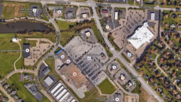
Retail Parking: A View from Google Earth
Google Earth can be a useful tool for understanding how parking is being used in your community and to identify where over- or under-utilization occurs.
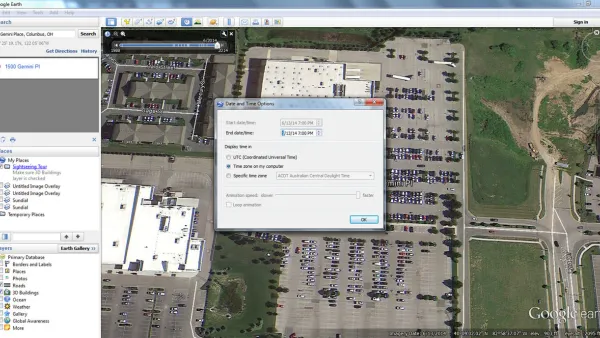
Using Google Earth to Understand Parking Utilization
As planners we use maps on a daily basis. This article shares how to find the date and time that a Google Earth image was taken, which can be helpful in undertaking site analysis and understanding parking utilization.

Analysis: Cybertruck Fatality Rate Far Exceeds That of Ford Pinto
The Tesla Cybertruck was recalled seven times last year.

National Parks Layoffs Will Cause Communities to Lose Billions
Thousands of essential park workers were laid off this week, just before the busy spring break season.

Retro-silient?: America’s First “Eco-burb,” The Woodlands Turns 50
A master-planned community north of Houston offers lessons on green infrastructure and resilient design, but falls short of its founder’s lofty affordability and walkability goals.

Test News Post 1
This is a summary

Analysis: Cybertruck Fatality Rate Far Exceeds That of Ford Pinto
The Tesla Cybertruck was recalled seven times last year.

Test News Headline 46
Test for the image on the front page.
Urban Design for Planners 1: Software Tools
This six-course series explores essential urban design concepts using open source software and equips planners with the tools they need to participate fully in the urban design process.
Planning for Universal Design
Learn the tools for implementing Universal Design in planning regulations.
EMC Planning Group, Inc.
Planetizen
Planetizen
Mpact (formerly Rail~Volution)
Great Falls Development Authority, Inc.
HUDs Office of Policy Development and Research
NYU Wagner Graduate School of Public Service