I had the opportuntity, at the 2009 national planning conference in Minneapolis, to present (together with my colleague Christian Peralta Madera) ten free web applications that can be used to support planning. Approximately 350 participants attended the session. Since the presentation, I've received over 100 emails congratulating us on the practical nature of the presentation, and requesting links to the websites we presented. Since our presentation was a hands-on demonstration, this blog entry outlines the ten technologies, and provides links to examples of the technology in practice and resources so you can experiment with the technologies.
I had the opportuntity, at the 2009 national planning conference in Minneapolis, to present (together with my colleague Christian Peralta Madera) ten free web applications that can be used to support planning.
Approximately 350 participants attended the session. Since the presentation, I've received over 100 emails congratulating us on the practical nature of the presentation, and requesting links to the websites we presented. Since our presentation was a hands-on demonstration, this blog entry outlines the ten technologies, and provides links to examples of the technology in practice and resources so you can experiment with the technologies.
Does Free Matter?
When a web application is "free", we are more easily able to experiment with the technology. Many of us have had the experience of trying to talk a manager into purchasing a new technology for us to try. Unless the manager is already aware of the technology or service, the justification and budgeting process can be complex, and can discourage experimentation. All of the following web applications are offered for free so that you can easily experiment with them. However, it's likely that if you plan to use a web application on behalf of your organization, you'll want to upgrade to the paid version. In most cases, the paid versions offer extra features and support.
Google Maps Mashups
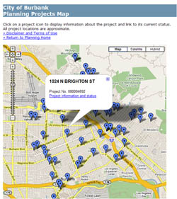 The term "mashup" comes from the music industry where a DJ (disc jockey) at a club combines music from two different records or CDs to create a new sound. In the technology industry, the term has been applied to combining different kinds of data in unique ways. Google Maps makes it very easy to combine your own data with a Google Map.
Examples
- City of Burbank Planning Projects http://www.burbankca.org/planning/projectsmap.html
- Grow Smart Maine Historic Properties http://www.growsmartmaine.org/maps/historic/index.asp
- Oral Histories of ROute 66: http://bit.ly/G6urK
- CrimeinDC http://www.crimeindc.org/
- Hawaii Tsunami Maps http://www5.hawaii.gov/tsunami/
- Navigate Hollywood http://www.NavigateHollywood.com/
- New York City Bike Maps http://www.nycbikemaps.com/maps/nyc-bike-map/
Resources
- Google Maps http://maps.google.com/
- Personalize Google Maps http://maps.google.com/help/maps/mymaps/create.html
- Batch Geocode http://www.batchgeocode.com (Useful for mapping your own points)
- Course: Building Google Maps Mashups: http://www.planetizen.com/courses/tech240
Video
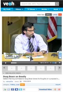 Most of us already recognize the power of video when we organize our day around our favorite television show. Video can be a powerful tool for community outreach. Just five years ago, the tools to capture, edit and display video was prohibitively expensive and complex for most of us. Today, the situation has changed dramatically with the advent of video sharing websites.
Examples
- Doug Boxer on Density: http://bit.ly/ABldC
- Insights into a Lively Downtown http://www.youtube.com/watch?v=VsrqBHEOT0k
- Andres Duany Lecture Series http://www.youtube.com/watch?v=rwd4Lq0Xvgc
- Plan Abu Dhabi http://www.youtube.com/watch?v=Yz-hguqZCKg
- Five Funny Planning YouTube Videos http://www.planetizen.com/node/35052
- Planning in Durango http://www.youtube.com/watch?v=nCZ_1dOFqPc
Resources
- YouTube http://www.youtube.com
- Vimeo http://www.vimeo.com
- Veoh http://www.veoh.com
- BlipTV http://www.blip.tv
- Planetizen Video for Planners Course http://www.planetizen.com/courses/plan175
Twitter
Twitter, sometimes called a "micro blog", enables you to distribute short messages of up to 140 characters in length to your "followers" -- friends, colleagues and anonymous others who choose to follow you. The service has become increasingly popular in the last several months. Twitter creator, Jack Dorsey, explains: "Twitter has been my life's work in many senses. It started with a fascination with cities and how they work, and what's going on in them right now."
Examples
- Eric Garcetti http://twitter.com/ericgarcetti
- magisplanning http://twitter.com/magisplanning
- Otis White: http://twitter.com/OtisWhite
- Planetizen: http://twitter.com/planetizen
- East Hollywood Neighborhood Council http://twitter.com/easthollywoodnc
- Follow APA2009 http://search.twitter.com/search?q=%23apa09
Resources
- Twitter http://www.twitter.com
Virtual Meetings
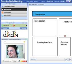 We've all had the experience of having to wake up extra early to fight traffic to make it to a meeting across town. But as project teams becoming increasingly diverse, in-person meetings are not always practical or a good use of time. Additionally, for some community members, participating in planning and design meetings during the day may not be possible. There are now a variety of free and low-cost options for holding virtual meetings, from a "webinar" style to full video conferencing where participants can collaborate on a whiteboard.
Resources
- DimDim http://www.dimdim.com
- GoToMeeting http://www.gotomeeting.com
- WebEx http://www.webex.com
- Live Meeting http://www.microsoft.com/livemeeting
- Yugma http://www.yugma.com
Wikis
Wikipedia has become a valuable resource for most of us, and is perhaps the most famous example of a wiki. A wiki is a set of linked pages that can be edited by any participant, but all changes are recorded so you can see every change that was made. Wikis are sometimes described as "the simplest online database that could possibly work", and the word wiki comes from the Hawaiian word for "fast".
 Examples
- FutureMelbourne Wiki: http://www.futuremelbourne.com.au
- Wikipedia entry for Urban Planning http://en.wikipedia.org/wiki/Urban_planning
- Seattle Transit Wiki http://www.seattletransitwiki.com/index.php?title=Main_Page
Resources
- PBWorks http://www.pbwiki.com
- Comparison of Wikis http://en.wikipedia.org/wiki/Comparison_of_wiki_software
- Wikis in Plain English http://www.youtube.com/watch?v=-dnL00TdmLY
Social Networking
Facebook, MySpace, Twitter, LinkedIn, Ning. Yikes. There are now so many ways for us to create and maintain connections with our friends and colleagues, it's sometimes hard to keep up with it all. Social media-savvy planners are increasingly using these social networking technologies to efficiently inform, educate and engage members of the community where they are gathering online.
Examples
- Jarvis Streetscape Improvement on Facebook http://www.facebook.com/group.php?gid=6949283325
- KC Greater Downtown Area Plan http://www.facebook.com/group.php?gid=135957535012
- Garden City Comprehensive Plan http://www.facebook.com/group.php?gid=68022919584
- East Harriet Farmstead Neighborhood Association http://www.facebook.com/group.php?gid=7091579820
Resources
- Facebook http://www.facebook.com
- LinkedIn http://www.linkedin.com
- MySpace http://www.myspace.com
- Social Networking in Plain English http://www.youtube.com/watch?v=6a_KF7TYKVc
-
Social Networking Websites http://en.wikipedia.org/wiki/List_of_social_networking_websites
Blogs
If you're reading this post, you already know what a blog is. Planetizen Interchange is a "group blog", where members of the planning community come together to discuss issues of concern to the community. The ability for readers to leave comments is an important part of many blogs, including this one. So please consider leaving a comment about your favorite web technology for planning at the end of this post.
Examples
- West Des Moines City Manager Blog http://wdmblog.wdm-ia.com/
- Miller Park http://millerparkseattle.blogspot.com/
- William Fulton http://fulton4ventura.blogspot.com/
- Cuyahoga County Planning Commission Weblog http://planning.co.cuyahoga.oh.us/blog/
- The Goodspeed Update http://www.goodspeedupdate.com/
- Planetizen Interchange Group Blog http://www.planetizen.com
- Planetizen Radar (Collection of recent blog posts) http://radar.planetizen.com
Resources
- WordPress http://www.wordpress.org
- Blogger http://www.blogger.com
- TypePad http://www.typepad.com
RSS & Alerts
These are admittedly the least exciting of the free web applications, but probably the most immediately useful to you. RSS stands for really simple syndication, and enables you to have news from your favorite websites collected and delivered to you in your web browser.
Google Alerts notify you whenever Google's search engine finds a news article, web page, blog entry or video about a word or phrase you tell it to look for. For example, if you're working on the the City of Tulsa Comphrensive Plan, why not set an alert for "PLANiTULSA" so that you know every time someone mentions it online?
Resources
- Google Reader http://reader.google.com
- Google Alerts http://www.google.com/alerts
Crowdsourcing
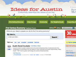 Crowdsourcing is taking a task traditionally performed by a single person, and inviting a large group or community to help complete the task. For example, companies will sometimes publish a thorny technical question, and offer a monetary reward to anyone who can solve it. The technologies that have evolved to meet these problem-solving needs are particularly well-suited to the field of planning, where we are often seeking ways to more effectively collect community input. Crowdsourcing websites allow the community to vote on which are the best ideas, or to submit new ideas for consideration by the community.
Examples
- Citizen's Briefing Book http://citizensbriefingbook.change.gov
- Obama's Urban Policy http://obamaurbanpolicy.obamacto.org/pages/6216
- Apps for Democracy http://insights.appsfordemocracy.org/pages/17582
- Planetizen, What should cities do with car lots? http://feedback.planetizen.com/pages/18468
- Ideas for Austin (no longer available) http://skitch.com/marcusnelson/bxkfd/21st-century-economy
- Next Stop Designz http://www.nextstopdesign.com, an experiment in crowdsourcing to improve public participation in transit planning.
- Peer to Patent http://peertopatent.org
Resources
- UserVoice http://www.uservoice.com
Texting/SMS
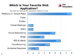 Text messaging or "texting" is the popular term for sending short text messages from the now ubiquitous mobile phones using the Short Message Service (SMS). Most people use texting to send person-to-person messages, but text message can also be used to participate in contests by voting (think American Idol), order products, or interact with automated systems. In some cases, texting might be used as a replacement for keypad polling, which is often used in planning, but can be expensive to setup. We used the Poll Everywhere service to enable participants in our conference session to text in their vote for the most popular technology presented during the session.
Examples
- Navigate Hollywood SMS Notifications http://www.navigatehollywood.com/alerts
Resources
- TextMarks http://www.textmarks.com
- Poll Everywhere http://www.polleverywhere.com
--
We're considering offering an hour-long webinar to provide a hands-on demonstration of each of these web applications. If you are interested in exploring more about how to use these technology for planning, please email me, and I'll let you know when we schedule the webinar.

National Parks Layoffs Will Cause Communities to Lose Billions
Thousands of essential park workers were laid off this week, just before the busy spring break season.

Retro-silient?: America’s First “Eco-burb,” The Woodlands Turns 50
A master-planned community north of Houston offers lessons on green infrastructure and resilient design, but falls short of its founder’s lofty affordability and walkability goals.

Delivering for America Plan Will Downgrade Mail Service in at Least 49.5 Percent of Zip Codes
Republican and Democrat lawmakers criticize the plan for its disproportionate negative impact on rural communities.

Test News Post 1
This is a summary

Test News Headline 46
Test for the image on the front page.

Balancing Bombs and Butterflies: How the National Guard Protects a Rare Species
The National Guard at Fort Indiantown Gap uses GIS technology and land management strategies to balance military training with conservation efforts, ensuring the survival of the rare eastern regal fritillary butterfly.
Urban Design for Planners 1: Software Tools
This six-course series explores essential urban design concepts using open source software and equips planners with the tools they need to participate fully in the urban design process.
Planning for Universal Design
Learn the tools for implementing Universal Design in planning regulations.
EMC Planning Group, Inc.
Planetizen
Planetizen
Mpact (formerly Rail~Volution)
Great Falls Development Authority, Inc.
HUDs Office of Policy Development and Research
NYU Wagner Graduate School of Public Service


