


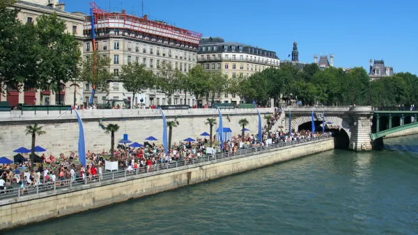
The executive director of the Philadelphia City Planning Commission says that the zoning "overlay" of the central Delaware waterfront will be replaced by a new master plan in 12 to 16 months.
"The Rules Committee gave its support yesterday to land-use measures setting aside property for public use and restricting the way it can be developed. Council is expected to vote on the changes by June 18, its last session before the summer break.
The zoning "overlay" would be replaced by a new master plan in 12 to 16 months, said Alan Greenberger, executive director of the City Planning Commission.
The interim measures apply to an area defined by Allegheny Avenue to the north, Oregon Avenue to the south, the river to the east, and I-95 to the west. They would:
Prohibit certain types of buildings along the waterfront, including bus terminals, big-box stores covering more than 40,000 square feet, parking garages, and self-storage facilities.
Set back development 100 feet from the river's edge to allow for pedestrian and bicycle traffic.
Require new commercial space fronting Delaware Avenue or Columbus Boulevard to have ground-floor uses such as stores or offices, lobbies, art or entertainment spaces.
Allow for public-access paths 12 to 25 feet wide from the street to the waterfront.
One controversial provision would prohibit the issuing of a zoning permit unless a developer has a plan of development approved by the Planning Commission.
That is the biggest problem, said Michael Sklaroff, chairman of the nonprofit Development Workshop, which represents the property owners as well as lawyers and other real estate professionals. He said projects would hinge on "the subjective review of the Planning Commission."
Sklaroff challenged the legality of the overlay. The Planning Commission, he said, lacks the authority under the city's Home Rule Charter to make zoning decisions.
Workshop members also argue that the bill would constitute the taking of private property without just compensation."
FULL STORY: Council panel advances Delaware waterfront measures


The Power of Urban Waterfronts
Humans' love of water makes waterways a particularly attractive urban amenity. Why did so many American cities let theirs languish?
River Scenes: How Rivers Contribute to More Vibrant Urban Communities
The role of rivers in urban areas shifted in recent years from production to consumption. Now, access to a river's waterfront has become a highly valued amenity within cities.
Walkable Waterfront Takes Shape on the Schuylkill River Near Philadelphia
The Pencoyd Landing development is focused on providing access to pedestrians, cyclists, and transit users in the neighborhood of Lower Merion Township, across the Schuylkill River from Philadelphia.

National Parks Layoffs Will Cause Communities to Lose Billions
Thousands of essential park workers were laid off this week, just before the busy spring break season.

Retro-silient?: America’s First “Eco-burb,” The Woodlands Turns 50
A master-planned community north of Houston offers lessons on green infrastructure and resilient design, but falls short of its founder’s lofty affordability and walkability goals.

Delivering for America Plan Will Downgrade Mail Service in at Least 49.5 Percent of Zip Codes
Republican and Democrat lawmakers criticize the plan for its disproportionate negative impact on rural communities.

Test News Post 1
This is a summary

Test News Headline 46
Test for the image on the front page.

Balancing Bombs and Butterflies: How the National Guard Protects a Rare Species
The National Guard at Fort Indiantown Gap uses GIS technology and land management strategies to balance military training with conservation efforts, ensuring the survival of the rare eastern regal fritillary butterfly.
Urban Design for Planners 1: Software Tools
This six-course series explores essential urban design concepts using open source software and equips planners with the tools they need to participate fully in the urban design process.
Planning for Universal Design
Learn the tools for implementing Universal Design in planning regulations.
EMC Planning Group, Inc.
Planetizen
Planetizen
Mpact (formerly Rail~Volution)
Great Falls Development Authority, Inc.
HUDs Office of Policy Development and Research
NYU Wagner Graduate School of Public Service