


Cities can expand transit service areas by providing convenient access by bike.
"The trouble with light rail and subway, some say, is that it only serves a small area around each station, and that vast areas can be left to dependence on cars. Planners consider mass transit service areas around light rail stations and subway stops to be about 1/4 mile - any farther and you'll see significantly diminishing interest in making the trek.
But that's for walking - and not biking.
A Rails to Trails Conservancy report from earlier this year addresses this very issue, noting that 'bicycling in particular has great potential to allow more people to access public transportation conveniently. Accessing public
transportation by bicycle can shorten travel times significantly. Because bicyclists travel about four times as fast as pedestrians, convenient access by bicycle can increase the geographic area served by one transit station 16-fold.'"
The article describes how places such as Minneapolis and Dallas are expanding transit service areas through trails.
FULL STORY: Trails and Transit: a Practical Combination

Transit, or Schools?
Atlanta school leaders consider renegotiating a Tax Allocation District (TAD) agreement that was set up to help fund projects such as the Beltline, a 22-mile loop of transit, trails, parks and development around the city.
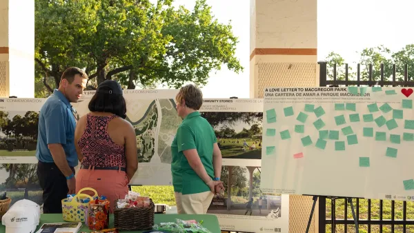
Public and Private Collaboration Advances Park Development in Houston
Houston may be known to some as a concrete jungle, but its greenspaces continue to expand thanks to combined support from the public, private, and philanthropic sectors.
After the Fires: Challenges and Efforts to Heal LA’s Parks and Trails
The recent LA wildfires have devastated parks and trails, with recovery efforts requiring extended closures, collaborative restoration plans, and community support to address extensive damage and long-term risks like landslides.

National Parks Layoffs Will Cause Communities to Lose Billions
Thousands of essential park workers were laid off this week, just before the busy spring break season.

Retro-silient?: America’s First “Eco-burb,” The Woodlands Turns 50
A master-planned community north of Houston offers lessons on green infrastructure and resilient design, but falls short of its founder’s lofty affordability and walkability goals.

Delivering for America Plan Will Downgrade Mail Service in at Least 49.5 Percent of Zip Codes
Republican and Democrat lawmakers criticize the plan for its disproportionate negative impact on rural communities.

Test News Post 1
This is a summary

Test News Headline 46
Test for the image on the front page.

Balancing Bombs and Butterflies: How the National Guard Protects a Rare Species
The National Guard at Fort Indiantown Gap uses GIS technology and land management strategies to balance military training with conservation efforts, ensuring the survival of the rare eastern regal fritillary butterfly.
Urban Design for Planners 1: Software Tools
This six-course series explores essential urban design concepts using open source software and equips planners with the tools they need to participate fully in the urban design process.
Planning for Universal Design
Learn the tools for implementing Universal Design in planning regulations.
EMC Planning Group, Inc.
Planetizen
Planetizen
Mpact (formerly Rail~Volution)
Great Falls Development Authority, Inc.
HUDs Office of Policy Development and Research
NYU Wagner Graduate School of Public Service