


This aerial view of part of Brasilia, Brazil's capital city, shows the paths of where people have crossed highways and literally made the road by walking.
"Although it's hard to prove conclusively, it looks like safety concerns played a part in determining where the highways were crossed. Several paths seem to converge at points where on-ramps and off-ramps are separated from the main flow of traffic. Crossing at these points allows the pedestrian to have breaks of median before having to make the next step. It looks as if some people have been willing to sacrifice a certain degree of time in order to cross a little more safely at one of these points."
Thanks to Streetsblog
FULL STORY: The walking paths of Brasilia

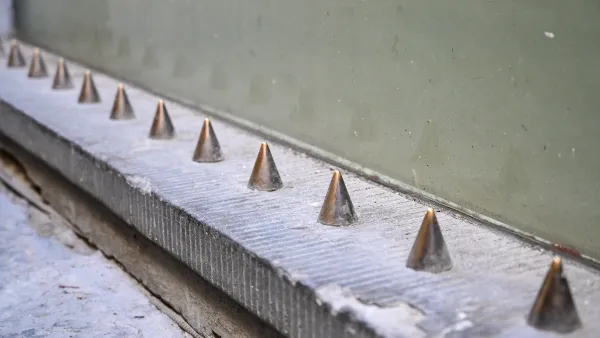
One Year Into Brazil’s ‘Hostile Architecture’ Ban
A recent law prohibits ‘defensive’ architecture designed to keep people away from buildings or public spaces.

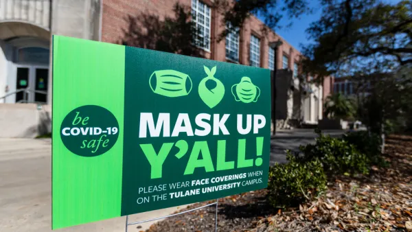
Senate Vote Illustrates America's Polarized Response to Pandemic
A Senate joint resolution to roll back the Biden administration's only vaccine mandate to be upheld by the Supreme Court passed on a party-line vote on March 2. In Europe, the legislative branch often needs to approve these measures to become law.
COVID Deaths: U.S. in a League of its Own
An analysis by The New York Times compares current and cumulative COVID deaths in the U.S. to other large, wealthy countries. Data analyzed include vaccination, age and obesity levels, and public trust, all factors that influence outcomes.

Analysis: Cybertruck Fatality Rate Far Exceeds That of Ford Pinto
The Tesla Cybertruck was recalled seven times last year.

National Parks Layoffs Will Cause Communities to Lose Billions
Thousands of essential park workers were laid off this week, just before the busy spring break season.

Retro-silient?: America’s First “Eco-burb,” The Woodlands Turns 50
A master-planned community north of Houston offers lessons on green infrastructure and resilient design, but falls short of its founder’s lofty affordability and walkability goals.

Test News Post 1
This is a summary

Analysis: Cybertruck Fatality Rate Far Exceeds That of Ford Pinto
The Tesla Cybertruck was recalled seven times last year.

Test News Headline 46
Test for the image on the front page.
Urban Design for Planners 1: Software Tools
This six-course series explores essential urban design concepts using open source software and equips planners with the tools they need to participate fully in the urban design process.
Planning for Universal Design
Learn the tools for implementing Universal Design in planning regulations.
EMC Planning Group, Inc.
Planetizen
Planetizen
Mpact (formerly Rail~Volution)
Great Falls Development Authority, Inc.
HUDs Office of Policy Development and Research
NYU Wagner Graduate School of Public Service