


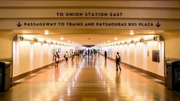
At the Automated Traffic Surveillance and Control center (ATSAC) near City Hall in Los Angeles, a team of engineers watches traffic flow all over the city, sucking in tons of data to improve transit and automotive circulation.
Ryan Bradley of GOOD pays a visit to ATSAC, which he says resembles the command centers one sees in movies and TV.
He writes, "ATSAC was created for two reasons. First, to adjust traffic signals in real time to respond to events that may cause congestion, like a car accident or a Lakers championship. Before ATSAC, the Department of Transportation had to send someone out into the field to adjust traffic signals. Now, these adjustments can be made throughout the city from this underground bunker next to City Hall, by those men watching those 16 screens, as thousands of cameras trained on thousands of intersections record the goings-on on the streets above."
The second goal of ATSAC, as Bradley points out, is to collect reams of data that can then be used to understand how traffic flows and where it can be improved.
Here's the the official page of ATSAC.
FULL STORY: Mark it good Walking in L.A.: The Data Driven City

Can LA Achieve a ‘No-Car’ Olympics?
The city’s mayor promises all Olympic venues will be reachable by transit, but the city’s ability to finish its transit projects on time is coming into question.
Congestion Pricing Could Be Coming to L.A.
The infamously car-centric city is weighing a proposed congestion pricing pilot program to reduce traffic and encourage public transit use.
Opinion: Los Angeles Must Prioritize Bikes and Buses
L.A. has a plan for improving mobility. Why are city leaders ignoring it?

National Parks Layoffs Will Cause Communities to Lose Billions
Thousands of essential park workers were laid off this week, just before the busy spring break season.

Retro-silient?: America’s First “Eco-burb,” The Woodlands Turns 50
A master-planned community north of Houston offers lessons on green infrastructure and resilient design, but falls short of its founder’s lofty affordability and walkability goals.

Delivering for America Plan Will Downgrade Mail Service in at Least 49.5 Percent of Zip Codes
Republican and Democrat lawmakers criticize the plan for its disproportionate negative impact on rural communities.

Test News Post 1
This is a summary

Test News Headline 46
Test for the image on the front page.

Balancing Bombs and Butterflies: How the National Guard Protects a Rare Species
The National Guard at Fort Indiantown Gap uses GIS technology and land management strategies to balance military training with conservation efforts, ensuring the survival of the rare eastern regal fritillary butterfly.
Urban Design for Planners 1: Software Tools
This six-course series explores essential urban design concepts using open source software and equips planners with the tools they need to participate fully in the urban design process.
Planning for Universal Design
Learn the tools for implementing Universal Design in planning regulations.
EMC Planning Group, Inc.
Planetizen
Planetizen
Mpact (formerly Rail~Volution)
Great Falls Development Authority, Inc.
HUDs Office of Policy Development and Research
NYU Wagner Graduate School of Public Service