


A new study finds that surface topography, not solely an area's underlying geology, contributes significantly to earthquake intensity. Researchers hope that the new information can be easily factored into local planning and design processes.
By studying the seismic forces and patterns of destruction to the built environment stemming from the magnitude 7.0 earthquake in the Haitian capital of Port-au-Prince ten months ago, a team of researchers has found that certain local surface features of an area's topography can have a substantial effect on an earthquake's intensity. These findings have important implications for planning and design of the built environment, especially in places of high seismic activity that are at high-risk of facing earthquake damage in the future.
The research team, led by Susan E. Hough of the United States Geological Survey, examined relationships between various natural topographical features in Port-au-Prince and the level of destruction to the buildings and other manmade structures sitting atop them. Accompanying computer simulations created from real-world data were also created by the researchers to pinpoint just how much movement can be expected on a ridge or slope of a certain height, for example. The findings should assist planners and scientists working to map out regions of the city that are at a higher level of risk in future quakes. This process has been dubbed 'microzonation.'
"In Haiti specifically, Dr. Hough said, scientists developing microzonation maps can now incorporate the topographic effects seen along the ridge in their work to help the country rebuild properly and better survive the next earthquake. And future earthquakes on or near the same fault are inevitable, seismologists say. "Potentially you can say, 'You should build over here, and not there,' " she said."
FULL STORY: In Studying Haiti, a New Angle on an Earthquake's Intensity

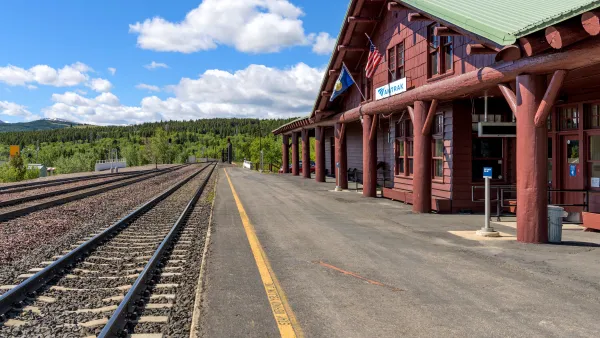
More Passenger Rail Coming to Montana
Planning is underway to restore a 45-year-defunct regional passenger rail line connecting southern Montana to Billings and Amtrak’s east-west Empire Builder line from Seattle to Chicago.

Elevating the ‘Small Stuff’ in Urban Design
Chuck Wolfe recaps arguments in favor of increased attention to incidentals — from benches to bollards — in urban development practices.

Los Angeles County Initiates Effort to Advance Equity in Infrastructure
L.A. County Public Works has launched an initiative to center equity in all of its processes, programming, and services as it plans, designs, builds, and maintains modern infrastructure that uplifts all communities of the county.

Analysis: Cybertruck Fatality Rate Far Exceeds That of Ford Pinto
The Tesla Cybertruck was recalled seven times last year.

National Parks Layoffs Will Cause Communities to Lose Billions
Thousands of essential park workers were laid off this week, just before the busy spring break season.

Retro-silient?: America’s First “Eco-burb,” The Woodlands Turns 50
A master-planned community north of Houston offers lessons on green infrastructure and resilient design, but falls short of its founder’s lofty affordability and walkability goals.

Test News Post 1
This is a summary

Analysis: Cybertruck Fatality Rate Far Exceeds That of Ford Pinto
The Tesla Cybertruck was recalled seven times last year.

Test News Headline 46
Test for the image on the front page.
Urban Design for Planners 1: Software Tools
This six-course series explores essential urban design concepts using open source software and equips planners with the tools they need to participate fully in the urban design process.
Planning for Universal Design
Learn the tools for implementing Universal Design in planning regulations.
EMC Planning Group, Inc.
Planetizen
Planetizen
Mpact (formerly Rail~Volution)
Great Falls Development Authority, Inc.
HUDs Office of Policy Development and Research
NYU Wagner Graduate School of Public Service