


This post from GOOD points to an old map of the Western U.S. in which state lines are redrawn based on the locations of watersheds.
It's an idea suggested in the 1880s by frontier explorer John Wesley Powell, but which never took hold.
"Powell saw that water management-mostly for irrigation-would be a pivotal issue throughout the arid Southwest, one that state governments would be wrestling with forever. So he proposed state boundaries based on watershed."
FULL STORY: John Wesley Powell's Watershed States Map

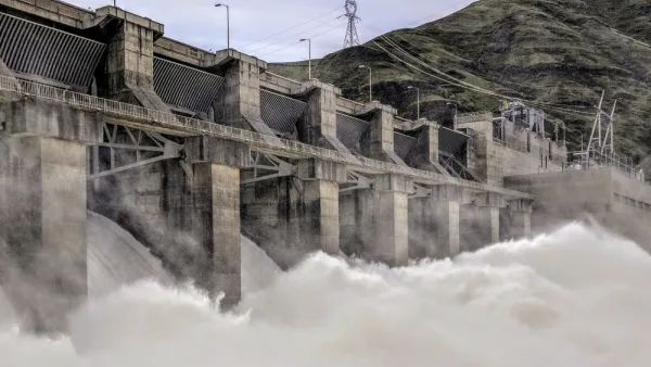
Congressional Bills Could Hit Refresh on U.S. Dams
The 21st Century Dams Act, a proposal to remove four dams on the lower Snake River, and the Infrastructure Investment and Jobs Act all have a chance to redefine the country's approach to dams and watersheds.

Water Recreation Brings $18 Billion Annually to Colorado
Water recreation is an important contributor to the state's economy. A recent report found that water-related activities contribute an annual $18 billion to the state's economy.
The United (Watershed) States of America
What if the great adventurer and geographer John Wesley Powell had his way: That as the western states were brought into the union their shape would be dictated by watershed rather than political boundary? This blog - and map - depict this scenario.

Analysis: Cybertruck Fatality Rate Far Exceeds That of Ford Pinto
The Tesla Cybertruck was recalled seven times last year.

National Parks Layoffs Will Cause Communities to Lose Billions
Thousands of essential park workers were laid off this week, just before the busy spring break season.

Retro-silient?: America’s First “Eco-burb,” The Woodlands Turns 50
A master-planned community north of Houston offers lessons on green infrastructure and resilient design, but falls short of its founder’s lofty affordability and walkability goals.

Test News Post 1
This is a summary

Analysis: Cybertruck Fatality Rate Far Exceeds That of Ford Pinto
The Tesla Cybertruck was recalled seven times last year.

Test News Headline 46
Test for the image on the front page.
Urban Design for Planners 1: Software Tools
This six-course series explores essential urban design concepts using open source software and equips planners with the tools they need to participate fully in the urban design process.
Planning for Universal Design
Learn the tools for implementing Universal Design in planning regulations.
EMC Planning Group, Inc.
Planetizen
Planetizen
Mpact (formerly Rail~Volution)
Great Falls Development Authority, Inc.
HUDs Office of Policy Development and Research
NYU Wagner Graduate School of Public Service