


Noah Kazis considers three success stories for public space in Mexico City, taking streets back from both automobiles and – believe it or not – street vendors.
Authorities in Mexico City have given three streets a major facelift, closing off traffic to cars and handing street life back to pedestrians.
The first, Calle Regina, had bigger problems to deal with than vehicular traffic. The street was crowded with vendors that, according to authorities, were affiliated with gangs. "As the administration of Mayor Marcelo Ebrard cleared the area, authorities found caches of drugs and guns," writes Kazis. "Different colored tarps announced which gangs protected each vendor. Only after removing the vendors could officials turn their attention to making Calle Regina car free."
Nearer the zócalo, or public square, on Calle Francisco I. Madero, the City's Public Space Authority faced a different challenge: business owners concerned that restricting traffic would cut into business. The Authority's head, Daniel Escotto, pleaded with the local chamber of commerce: "Let me just have one day, with cones," he recalls. When the program began, Calle Madero was closed once a week, on Mondays. Within two weeks, it was Tuesdays, too. Just three months later, the street was repaved to eliminate its curbs, in a gesture of commitment to its new, pedestrian-only status.
Lastly, to celebrate the bicentennial of the Mexican Revolution, officials approved pedestrian-friendly improvements to the monumental Plaza de la República. "Sidewalks were widened and beautified with new street furniture and plantings. Plaza space once given over to car parking was reclaimed, creating room for amenities like a new fountain."
The next step, according to Escotto, is to remove all four lanes of vehicular traffic surrounding the Plaza by the end of 2012, dedicating the space exclusively to pedestrians.
FULL STORY: How Mexico City Fought and Cajoled to Reclaim Streets for Pedestrians

Mexico City Raises Mobility, Public Works Budget Ahead of World Cup
The Mexican capital plans to improve mobility to its major sports venues and invest in public works and infrastructure.
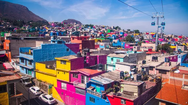
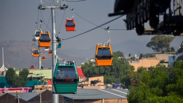
Mexico City Aerial ‘Cablebus’ Provides Key Connection to Peripheral Neighborhoods
Unlike many aerial gondolas, Mexico City’s Cablebus is largely used by commuters and residents from communities farther from the city center.

Rooftop Solar on Mexico City Market to Power 300 Transit Buses
A solar project atop a massive food market will provide electricity to Mexico City's public transit buses.

National Parks Layoffs Will Cause Communities to Lose Billions
Thousands of essential park workers were laid off this week, just before the busy spring break season.

Retro-silient?: America’s First “Eco-burb,” The Woodlands Turns 50
A master-planned community north of Houston offers lessons on green infrastructure and resilient design, but falls short of its founder’s lofty affordability and walkability goals.

Delivering for America Plan Will Downgrade Mail Service in at Least 49.5 Percent of Zip Codes
Republican and Democrat lawmakers criticize the plan for its disproportionate negative impact on rural communities.

Test News Post 1
This is a summary

Test News Headline 46
Test for the image on the front page.

Balancing Bombs and Butterflies: How the National Guard Protects a Rare Species
The National Guard at Fort Indiantown Gap uses GIS technology and land management strategies to balance military training with conservation efforts, ensuring the survival of the rare eastern regal fritillary butterfly.
Urban Design for Planners 1: Software Tools
This six-course series explores essential urban design concepts using open source software and equips planners with the tools they need to participate fully in the urban design process.
Planning for Universal Design
Learn the tools for implementing Universal Design in planning regulations.
EMC Planning Group, Inc.
Planetizen
Planetizen
Mpact (formerly Rail~Volution)
Great Falls Development Authority, Inc.
HUDs Office of Policy Development and Research
NYU Wagner Graduate School of Public Service