


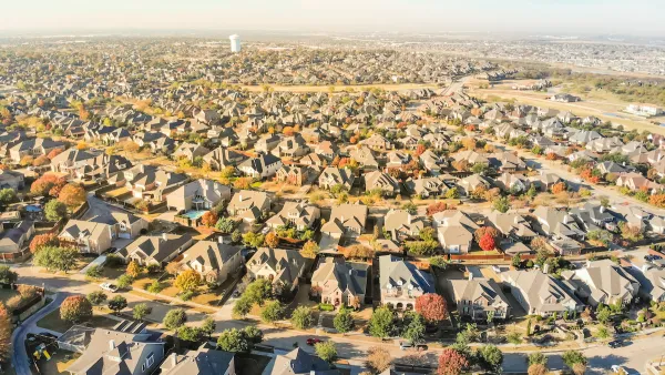
In an opinion piece for The New York Times, Christopher B. Leinberger summarizes a new report he's co-authored for the Brookings Institution that demonstrates the correlation between walkability and real estate value.
Leinberger's new study, co-authored with Mariela Alfonzo, compared the values of commercial and residential real estate in the Washington, D.C. metropolitan area with an area's walkability; and their findings have proven the reversal of the common understanding of where the most valuable real estate can be found.
"Our research shows that real estate values increase as neighborhoods
became more walkable, where everyday needs, including working, can be
met by walking, transit or biking. There is a five-step 'ladder' of
walkability, from least to most walkable. On average, each step up the
walkability ladder adds $9 per square foot to annual office rents, $7
per square foot to retail rents, more than $300 per month to apartment
rents and nearly $82 per square foot to home values."
And walkable doesn't have to mean downtown. "Demand for walkable urban space extends beyond city centers to suburbs;
in metropolitan Washington, more than half of the walkable places are in
the suburbs, like Reston Town Center, 22 miles from downtown
Washington; Ballston, in Arlington County; and Silver Spring, in
suburban Maryland."
The flip side of the rising value of walkable places in the accompanying loss of affordable housing that many cities are struggling with. Leinberger proposes some short and long-term strategies for improving affordability. "To address the affordability challenge, a sensible strategy would
include changes like zoning that allows homes with units in the back or
over the garage. But the long-term solution is encouraging the building
of more walkable places, which will reduce the price premiums by
creating more supply."
FULL STORY: Now Coveted: A Walkable, Convenient Place


Rethinking Suburban Development: New Trends in Creating Livable Communities
Discover new trends in suburban development focused on creating more livable, sustainable communities for future growth.

Midburbs: A New Definition of Suburbs
When the name “suburb” just doesn't quite fit.
Zoning for Good
A new book highlights the power of zoning to change communities for the better.

National Parks Layoffs Will Cause Communities to Lose Billions
Thousands of essential park workers were laid off this week, just before the busy spring break season.

Retro-silient?: America’s First “Eco-burb,” The Woodlands Turns 50
A master-planned community north of Houston offers lessons on green infrastructure and resilient design, but falls short of its founder’s lofty affordability and walkability goals.

Delivering for America Plan Will Downgrade Mail Service in at Least 49.5 Percent of Zip Codes
Republican and Democrat lawmakers criticize the plan for its disproportionate negative impact on rural communities.

Test News Post 1
This is a summary

Test News Headline 46
Test for the image on the front page.

Balancing Bombs and Butterflies: How the National Guard Protects a Rare Species
The National Guard at Fort Indiantown Gap uses GIS technology and land management strategies to balance military training with conservation efforts, ensuring the survival of the rare eastern regal fritillary butterfly.
Urban Design for Planners 1: Software Tools
This six-course series explores essential urban design concepts using open source software and equips planners with the tools they need to participate fully in the urban design process.
Planning for Universal Design
Learn the tools for implementing Universal Design in planning regulations.
EMC Planning Group, Inc.
Planetizen
Planetizen
Mpact (formerly Rail~Volution)
Great Falls Development Authority, Inc.
HUDs Office of Policy Development and Research
NYU Wagner Graduate School of Public Service