


A new exhibit that opened this week at the San Francisco Planning and Urban Research Association's gallery explores the 10 diagrams that have had a monumental influence on urban planning, and the possibilities inherent in the medium.
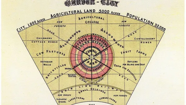
Emily Badger surveys the 10 highly influential diagrams - from Ebenezer Howard's Garden City to Le Corbusier's Radiant City to the Transect - that comprise SPUR's new exhibition, "Grand Reductions: Ten diagrams that changed urban planning." She also examines the possibilities, both positive and negative, inherent in a "simple illustration's power to encapsulate complex ideas."
"In the urban context, diagrams can be powerful precisely because they
make weighty questions of land use and design digestible in a single
sweep of the eye," notes Badger. "But as Le Corbusier's plan illustrates, they can also
seductively oversimplify the problems of cities."
"The diagram can cut both ways: It can either be a distillation in the
best sense of really taking a very complex set of issues and providing
us with a very elegant communication of the solution," says Benjamin Grant, the public realm and urban design program manager for SPUR. "Or
it can artificially simplify something that actually needs to be
complex."
The exhibit is on show until February 15, 2013 at the SPUR Urban Center Gallery, 654 Mission Street, San Francisco.
FULL STORY: The Evolution of Urban Planning in 10 Diagrams


The Evolution of Green Urbanism
Today’s "Eco" or "Green" Urbanism movement has ancient, cross-cultural roots. This history is worth contemplating for lessons relevant to sustainable planning and design.
Are Garden Cities Sustainable?
The Garden City concept has a long and honorable pedigree within urban planning. Analysis of Sterling Ranch, a master-planned community outside of Denver, Colorado highlights some important issues around social and environmental sustainability.

Clash Over Garden City Apartments in Los Angeles
The Wyvernwood Garden Apartments, a large-scale low-rise development opened in 1939, are at the center of a preservation debate. Lauren Walser gives us the case for keeping them.

National Parks Layoffs Will Cause Communities to Lose Billions
Thousands of essential park workers were laid off this week, just before the busy spring break season.

Retro-silient?: America’s First “Eco-burb,” The Woodlands Turns 50
A master-planned community north of Houston offers lessons on green infrastructure and resilient design, but falls short of its founder’s lofty affordability and walkability goals.

Delivering for America Plan Will Downgrade Mail Service in at Least 49.5 Percent of Zip Codes
Republican and Democrat lawmakers criticize the plan for its disproportionate negative impact on rural communities.

Test News Post 1
This is a summary

Test News Headline 46
Test for the image on the front page.

Balancing Bombs and Butterflies: How the National Guard Protects a Rare Species
The National Guard at Fort Indiantown Gap uses GIS technology and land management strategies to balance military training with conservation efforts, ensuring the survival of the rare eastern regal fritillary butterfly.
Urban Design for Planners 1: Software Tools
This six-course series explores essential urban design concepts using open source software and equips planners with the tools they need to participate fully in the urban design process.
Planning for Universal Design
Learn the tools for implementing Universal Design in planning regulations.
EMC Planning Group, Inc.
Planetizen
Planetizen
Mpact (formerly Rail~Volution)
Great Falls Development Authority, Inc.
HUDs Office of Policy Development and Research
NYU Wagner Graduate School of Public Service