


Recently a destination for luxury development, New York's waterfront has historically been home to the city's poor. When Sandy inundated these vulnerable populations, it "looked like a perverse stroke of urban planning," writes Jonathan Mahler.
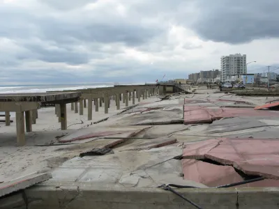
"How is it possible that the same winding, 538-mile coastline that has recently been colonized by condominium developers chasing wealthy New Yorkers, themselves chasing waterfront views, had been, for decades, a catch basin for many of the city’s poorest residents?" asks Mahler. In an essay for the Times, he answers his question by surveying the history of "accident, grand vision and political expedience," that led to public housing projects sprouting in close proximity to the water in such areas as the Rockaways, Coney Island, Red Hook and Alphabet City.
"New York started building housing projects on the waterfront because that’s where its poorest citizens happened to live. It continued because that’s where space was most readily available. Finally, it built them there because that’s where its projects already were."
Smack dab in the middle of this sequence sits Robert Moses. "It’s impossible to talk about the landscape of modern New York without talking about Moses," says Mahler, "who leveraged his position as head of the Mayor’s Committee on Slum Clearance to mass-produce thousands of units of high-rise public housing, often near the shoreline. His shadow looms over much of the havoc wreaked by the storm."
FULL STORY: How the Coastline Became a Place to Put the Poor


Analysis: Cybertruck Fatality Rate Far Exceeds That of Ford Pinto
The Tesla Cybertruck was recalled seven times last year.

National Parks Layoffs Will Cause Communities to Lose Billions
Thousands of essential park workers were laid off this week, just before the busy spring break season.

Retro-silient?: America’s First “Eco-burb,” The Woodlands Turns 50
A master-planned community north of Houston offers lessons on green infrastructure and resilient design, but falls short of its founder’s lofty affordability and walkability goals.

Test News Post 1
This is a summary

Analysis: Cybertruck Fatality Rate Far Exceeds That of Ford Pinto
The Tesla Cybertruck was recalled seven times last year.

Test News Headline 46
Test for the image on the front page.
Urban Design for Planners 1: Software Tools
This six-course series explores essential urban design concepts using open source software and equips planners with the tools they need to participate fully in the urban design process.
Planning for Universal Design
Learn the tools for implementing Universal Design in planning regulations.
EMC Planning Group, Inc.
Planetizen
Planetizen
Mpact (formerly Rail~Volution)
Great Falls Development Authority, Inc.
HUDs Office of Policy Development and Research
NYU Wagner Graduate School of Public Service