


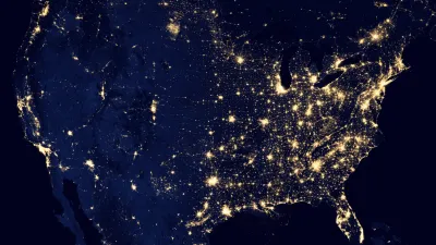
This week, scientists unveiled unprecedented images of the Earth at night, as captured by a new NASA and National Oceanic and Atmospheric Administration (NOAA) satellite.
Assembled from data acquired by the NASA-NOAA Suomi National Polar-orbiting Partnership (NPP) satellite in April and October 2012, the stunning images unveiled at this week's American Geophysical Union meeting in San Francisco, show "the glow of natural and human-built phenomena across the planet in greater detail than ever before."
According to NASA, the satellite, which was launched last year, is equipped with a new sensor (VIIRS) that "is sensitive enough to detect the nocturnal glow produced by Earth's atmosphere and the light from a single ship in the sea."
"'For all the reasons that we need to see Earth during the day, we also need to see Earth at night,' said Steve Miller, a researcher at NOAA's Colorado State University Cooperative Institute for Research in the Atmosphere. 'The night is nowhere as dark as we might think,' Miller said. And with the VIIRS day-night band helping scientists to tease out information from human and natural sources of nighttime light, 'we don't have to be in the dark anymore, either.'"
For a critical take on what the images reveal about politics, the environment and borders, see Olga Khazan's piece in The Washington Post.
FULL STORY: NASA-NOAA Satellite Reveals New Views of Earth at Night


How Effective Street Lighting Improves Women’s Mobility
A lack of effective lighting in streets, parks, and transit stations limits the places where many women and other vulnerable groups feel safe traveling at night.

NOAA Awards $575M in Coastal Resilience Grants
The program received over $16 billion in requests from communities around the country.

What Does Sustainability Mean in Space?
NASA is developing a sustainability strategy to clean up space debris and plan for the future as near-earth orbit becomes more cluttered.

National Parks Layoffs Will Cause Communities to Lose Billions
Thousands of essential park workers were laid off this week, just before the busy spring break season.

Retro-silient?: America’s First “Eco-burb,” The Woodlands Turns 50
A master-planned community north of Houston offers lessons on green infrastructure and resilient design, but falls short of its founder’s lofty affordability and walkability goals.

Delivering for America Plan Will Downgrade Mail Service in at Least 49.5 Percent of Zip Codes
Republican and Democrat lawmakers criticize the plan for its disproportionate negative impact on rural communities.

Test News Post 1
This is a summary

Test News Headline 46
Test for the image on the front page.

Balancing Bombs and Butterflies: How the National Guard Protects a Rare Species
The National Guard at Fort Indiantown Gap uses GIS technology and land management strategies to balance military training with conservation efforts, ensuring the survival of the rare eastern regal fritillary butterfly.
Urban Design for Planners 1: Software Tools
This six-course series explores essential urban design concepts using open source software and equips planners with the tools they need to participate fully in the urban design process.
Planning for Universal Design
Learn the tools for implementing Universal Design in planning regulations.
EMC Planning Group, Inc.
Planetizen
Planetizen
Mpact (formerly Rail~Volution)
Great Falls Development Authority, Inc.
HUDs Office of Policy Development and Research
NYU Wagner Graduate School of Public Service