


The increased proximity provided by more compact and centralized development is about ten times more influential than vehicle traffic speed on the number of destinations that people can reach within a given travel time.
Researchers analyzed the number of destinations that can be accessed within a given amount of travel time by mode (automobile and transit) and purpose (work and non-work trips) for about 30 US metropolitan areas. They found that although denser urban development tends to reduce vehicle travel speeds, the increased proximity is about ten times more influential than travel speed in determining a metropolitan area’s overall accessibility. This indicates that smart growth policies which increase development density and mix, transport network connectivity, and transport system diversity can do more to improve overall transport system performance than efforts to increase traffic speeds and reduce congestion.
The authors conclude, "Having destinations nearby, as when densities are high, offers benefits even when the associated congestion slows traffic. Where land use policy frequently seeks to support low-development densities in part in an attempt to maintain travel speeds and forestall traffic congestion, our findings suggest that compact development can often improve transportation outcomes."

Toward More Comprehensive Understanding of Traffic Congestion
Conventional planning tends to consider traffic congestion asignificant cost and roadway expansion the preferred solution. It evaluates transport system performance based on indicators such as roadway Level of Service (LOS) and peak-period traffic

New Orleans Makes Push for Accessibility Improvements Ahead of Super Bowl
Major sporting events like the Olympics and the Super Bowl can serve as catalysts for major changes in transportation infrastructure and accessibility.
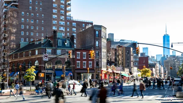
Planning for Accessibility: Proximity is More Important than Mobility
Accessibility-based planning minimizes the distance that people must travel to reach desired services and activities. Measured this way, increased density can provide more total benefits than increased speeds.

National Parks Layoffs Will Cause Communities to Lose Billions
Thousands of essential park workers were laid off this week, just before the busy spring break season.

Retro-silient?: America’s First “Eco-burb,” The Woodlands Turns 50
A master-planned community north of Houston offers lessons on green infrastructure and resilient design, but falls short of its founder’s lofty affordability and walkability goals.

Delivering for America Plan Will Downgrade Mail Service in at Least 49.5 Percent of Zip Codes
Republican and Democrat lawmakers criticize the plan for its disproportionate negative impact on rural communities.

Test News Post 1
This is a summary

Test News Headline 46
Test for the image on the front page.

Balancing Bombs and Butterflies: How the National Guard Protects a Rare Species
The National Guard at Fort Indiantown Gap uses GIS technology and land management strategies to balance military training with conservation efforts, ensuring the survival of the rare eastern regal fritillary butterfly.
Urban Design for Planners 1: Software Tools
This six-course series explores essential urban design concepts using open source software and equips planners with the tools they need to participate fully in the urban design process.
Planning for Universal Design
Learn the tools for implementing Universal Design in planning regulations.
EMC Planning Group, Inc.
Planetizen
Planetizen
Mpact (formerly Rail~Volution)
Great Falls Development Authority, Inc.
HUDs Office of Policy Development and Research
NYU Wagner Graduate School of Public Service