


In this fascinating photo essay, Jordi Sanchez-Cuenca explores Mexico City's urban morphology. Seemingly every type of urban form known to man can be found within the Mexican capital's boundaries.
In neighborhoods planned and unplanned, in a variety of geometric shapes and amoebic growths, Mexico City's 20 million residents live in a seemingly endless variety of neighborhoods. Sanchez-Cuenca documents the diversity using aerial images. Interesting dichotomies can be discerned from 30,000 feet: between the modern and the historic, affluent and impoverished, natural and urban.
For instance, says Sanchez-Cuenca, "Modernist planning is still alive in Mexico, where planners appear to have substantial power in society. The challenge of resettling so many families in so few years has been solved through standardization. Many new settlements resemble enlarged microchips."
"Other developments — like Geovillas Santa Bárbara (above) — have curved streets and more diverse layouts, but they are usually for higher-income populations."
Sanchez-Cuenca concludes her essay by arguing for a new approach to planning for the city's poor — "one that empowers informal communities without imposing insensitive planning from above, addressing the roots of urban poverty instead of formalizing it."
FULL STORY: Urban Morphology in Mexico City


Learning From Venice, Florida
How a community planned in the 1920s has gracefully navigated change, offering a model for other places.
Mexico City Raises Mobility, Public Works Budget Ahead of World Cup
The Mexican capital plans to improve mobility to its major sports venues and invest in public works and infrastructure.

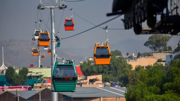
Mexico City Aerial ‘Cablebus’ Provides Key Connection to Peripheral Neighborhoods
Unlike many aerial gondolas, Mexico City’s Cablebus is largely used by commuters and residents from communities farther from the city center.

National Parks Layoffs Will Cause Communities to Lose Billions
Thousands of essential park workers were laid off this week, just before the busy spring break season.

Retro-silient?: America’s First “Eco-burb,” The Woodlands Turns 50
A master-planned community north of Houston offers lessons on green infrastructure and resilient design, but falls short of its founder’s lofty affordability and walkability goals.

Delivering for America Plan Will Downgrade Mail Service in at Least 49.5 Percent of Zip Codes
Republican and Democrat lawmakers criticize the plan for its disproportionate negative impact on rural communities.

Test News Post 1
This is a summary

Test News Headline 46
Test for the image on the front page.

Balancing Bombs and Butterflies: How the National Guard Protects a Rare Species
The National Guard at Fort Indiantown Gap uses GIS technology and land management strategies to balance military training with conservation efforts, ensuring the survival of the rare eastern regal fritillary butterfly.
Urban Design for Planners 1: Software Tools
This six-course series explores essential urban design concepts using open source software and equips planners with the tools they need to participate fully in the urban design process.
Planning for Universal Design
Learn the tools for implementing Universal Design in planning regulations.
EMC Planning Group, Inc.
Planetizen
Planetizen
Mpact (formerly Rail~Volution)
Great Falls Development Authority, Inc.
HUDs Office of Policy Development and Research
NYU Wagner Graduate School of Public Service