


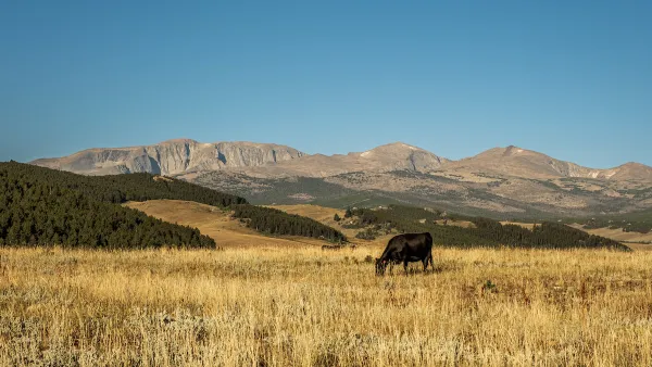
A new study finds that high commodity prices and a biofuels rush have led to rates of grassland loss in America's northern Plains “comparable to deforestation rates in Brazil, Malaysia, and Indonesia.” Brad Plumer discusses the impacts.
"A new study by Christopher Wright and Michael Wimberly of South Dakota State University finds that U.S. farmers converted more than 1.3 million acres of grassland into corn and soybean fields between 2006 and 2011," writes Plumer. As up to five percent of grasslands in some states are converted to cropland each year, the northern Plains are confronting unexpected problems.
For example, notes Plumer, the loss of pasture could have big environmental impacts. "Studies have found that grasslands hold carbon in their soil better than cropland does."
"There’s a wildlife angle, too: The Prairie Pothole Region, traversing Minnesota and the Dakotas, is one of the continent’s key breeding grounds for ducks and other ground-nesting birds. Tall grasses in the area help sustain a number of species and shield birds from predators. But corn fields are now encroaching on the habitat, and bird populations are dropping."
FULL STORY: Biofuel rush wiping out America’s grasslands at fastest pace since the 1930s

Montana Ranchers Question Massive Solar Project
The $1.2-billion solar farm would provide power to data centers owned by Microsoft, Meta, and others.

Industry Leaders: Automakers Must Cut EV Battery Weight in Half
Experts call for lighter batteries, diversification of fuels, and a shift away from private cars and towrad public transit.
Former Landfill Doubles as Public Park, Energy Producer
Once the world’s largest dump, Freshkills Park now offers new city park space and powers local households with biofuel.

National Parks Layoffs Will Cause Communities to Lose Billions
Thousands of essential park workers were laid off this week, just before the busy spring break season.

Retro-silient?: America’s First “Eco-burb,” The Woodlands Turns 50
A master-planned community north of Houston offers lessons on green infrastructure and resilient design, but falls short of its founder’s lofty affordability and walkability goals.

Delivering for America Plan Will Downgrade Mail Service in at Least 49.5 Percent of Zip Codes
Republican and Democrat lawmakers criticize the plan for its disproportionate negative impact on rural communities.

Test News Post 1
This is a summary

Test News Headline 46
Test for the image on the front page.

Balancing Bombs and Butterflies: How the National Guard Protects a Rare Species
The National Guard at Fort Indiantown Gap uses GIS technology and land management strategies to balance military training with conservation efforts, ensuring the survival of the rare eastern regal fritillary butterfly.
Urban Design for Planners 1: Software Tools
This six-course series explores essential urban design concepts using open source software and equips planners with the tools they need to participate fully in the urban design process.
Planning for Universal Design
Learn the tools for implementing Universal Design in planning regulations.
EMC Planning Group, Inc.
Planetizen
Planetizen
Mpact (formerly Rail~Volution)
Great Falls Development Authority, Inc.
HUDs Office of Policy Development and Research
NYU Wagner Graduate School of Public Service