


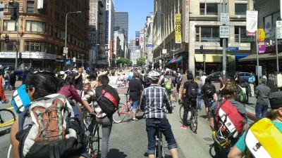
Sunday saw the sixth incarnation of L.A.'s popular CicLAvia event, which closes long stretches of city streets to automobile traffic, and opens them to bikes and pedestrians. The latest route, from downtown to the sea, attracted 150,000 people.
Modeled on Ciclovia, a 30-year-old open streets event held in Bogota, Colombia, CicLAvia provides an opportunity for Angelenos to share in the city's burgeoning bicycle culture, see their city in a different way, and appreciate the variety of modes who seek to utilize the city's streets.
After five successful events held over the last three years in central Los Angeles, last weekend's event was the first in which street closures extended all the way to the ocean. And a record crowd estimated at 150,000 took advantage of the closure of Venice Boulevard, "a streetcar route in the bygone era of Los Angeles' Red Cars."
"With an eye on his legacy in the waning days of his eight years in office, Mayor Antonio Villaraigosa described the event as emblematic of a city reducing its reliance on the automobile, with 148 miles of new bike lanes and a rapidly expanding network of rail lines," say Michael Finnegan, Samantha Schaefer and Abby Sewell.
"It's not a walkable city yet, but it's becoming a walkable city," said Villaraigosa.
FULL STORY: Non-drivers hog the road at 6th and biggest CicLAvia


LA Metro Could Slash Open Streets Funding
Despite the program’s success across the region and rising production costs, Los Angeles-area events could receive less funding in the coming year.

CicLAvia Helping Restaurants Keep Outdoor Dining
CicLAvia is working with the city to make its "al fresco dining" program permanent.

CicLAvia: Reclaiming Streets in the Car Capital of America
The second in a series profiling grassroots activism to increase biking among the diverse populations of Los Angeles County. In this installment, Planetizen spoke with Robert Gard, director of communications for CicLAvia.

National Parks Layoffs Will Cause Communities to Lose Billions
Thousands of essential park workers were laid off this week, just before the busy spring break season.

Retro-silient?: America’s First “Eco-burb,” The Woodlands Turns 50
A master-planned community north of Houston offers lessons on green infrastructure and resilient design, but falls short of its founder’s lofty affordability and walkability goals.

Delivering for America Plan Will Downgrade Mail Service in at Least 49.5 Percent of Zip Codes
Republican and Democrat lawmakers criticize the plan for its disproportionate negative impact on rural communities.

Test News Post 1
This is a summary

Test News Headline 46
Test for the image on the front page.

Balancing Bombs and Butterflies: How the National Guard Protects a Rare Species
The National Guard at Fort Indiantown Gap uses GIS technology and land management strategies to balance military training with conservation efforts, ensuring the survival of the rare eastern regal fritillary butterfly.
Urban Design for Planners 1: Software Tools
This six-course series explores essential urban design concepts using open source software and equips planners with the tools they need to participate fully in the urban design process.
Planning for Universal Design
Learn the tools for implementing Universal Design in planning regulations.
EMC Planning Group, Inc.
Planetizen
Planetizen
Mpact (formerly Rail~Volution)
Great Falls Development Authority, Inc.
HUDs Office of Policy Development and Research
NYU Wagner Graduate School of Public Service