


Parking regulations are generally formulated as uniform standards that apply to hundreds or thousands of parcels equally, often resulting in overbuilt supply. But what if planners could anticipate the parking demand down to the parcel?

As Emily Badger reports, Seattle's King County Metro Transit agency, with the help of the Center for Neighborhood Technology and the Urban Land Institute Northwest, have been working on solving the parking supply vs. demand conundrum and may have achieved a significant breakthrough.
"They've spent the past year trying to measure exactly which factors dictate residential parking demand around the region, in downtown Seattle, in urban neighborhoods, in the suburbs and even farther out. The result of their efforts is this Right Size Parking Calculator web application that can estimate parking demand down to a single parcel of land (and that should be replicated in other cities)," she writes.
"The idea is that developers might use the tool when planning a project," she adds, "but also that local governments might consider this data in updating their parking regulations. King Country is agnostic about what they come up with."
"The name 'Right Size' is very conscious because we don’t want to just say 'in all cases there should be less parking,'" says Ron Posthuma, the assistant director of the King County Department of Transportation. "In some cases, maybe there should be more."
FULL STORY: Mapping the Subtle Science of Parking Demand

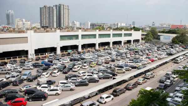
Parking Inventories for Five Cities
A new report providing credible estimates of five cities of differing size and geographic location reveals one truth about the United States: parking is the dominant land use in cities.

Fun Parking Facts
Parking requirements are the dark matter of the urban universe: they affect transport and land use in mysterious ways. These fun facts illustrate the costs and impacts of economically excessive parking supply.
Study: There's Too Much Parking in Chicago
With underground parking spaces costing $37,000 and more to build in Chicago, it might come as a shock that a recent study found much more parking supply than demand around the city's apartment buildings.

National Parks Layoffs Will Cause Communities to Lose Billions
Thousands of essential park workers were laid off this week, just before the busy spring break season.

Retro-silient?: America’s First “Eco-burb,” The Woodlands Turns 50
A master-planned community north of Houston offers lessons on green infrastructure and resilient design, but falls short of its founder’s lofty affordability and walkability goals.

Delivering for America Plan Will Downgrade Mail Service in at Least 49.5 Percent of Zip Codes
Republican and Democrat lawmakers criticize the plan for its disproportionate negative impact on rural communities.

Test News Post 1
This is a summary

Test News Headline 46
Test for the image on the front page.

Balancing Bombs and Butterflies: How the National Guard Protects a Rare Species
The National Guard at Fort Indiantown Gap uses GIS technology and land management strategies to balance military training with conservation efforts, ensuring the survival of the rare eastern regal fritillary butterfly.
Urban Design for Planners 1: Software Tools
This six-course series explores essential urban design concepts using open source software and equips planners with the tools they need to participate fully in the urban design process.
Planning for Universal Design
Learn the tools for implementing Universal Design in planning regulations.
EMC Planning Group, Inc.
Planetizen
Planetizen
Mpact (formerly Rail~Volution)
Great Falls Development Authority, Inc.
HUDs Office of Policy Development and Research
NYU Wagner Graduate School of Public Service