


By removing auto traffic from two key streets, the plan for a 10-acre park in the heart of downtown Cleveland seeks to weave together the city's 'lackluster' Public Square and help boost a downtown revival.
James Corner Field Operations, Cleveland-based LAND Studio, and transportation consulting firm Nelson/Nygaard have developed an ambitious scheme to unite the four disconnected squares that make up Cleveland's historic Public Square by closing Ontario Street and Superior Avenue to automobiles. "In the design, tree-lined pathways and grassy hills weave the square together," explains Chris Bentley. "The programming aims to make it a true civic space."
"While redevelopment efforts in the 1990s failed to produce the public interest that comes with a true civic renewal, planners today are focused on parks and cultural experiences," he adds. "The designers of Public Square hope to unite citywide development gains, stitching together a lively downtown with a leafy civic space."
“We’re trying to optimize all of these catalytic projects that are happening around Public Square,” said LAND Studio senior project director Nora Romanoff. “If we’re doing our job right, absolutely this is a park that spurs all of these other things that have nothing to do with the park, but at the same time have everything to do with the park.”
FULL STORY: ONE PARK TO BIND THEM ALL

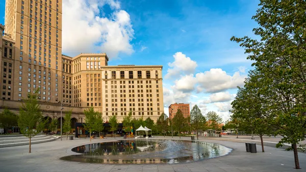
Cleveland's Renovated Public Square Opening June 30
The $50 million renovation of Cleveland's Public Square, designed by James Corner Field Operations, will open in time for the Republican National Convention.
An In-Depth Look at One of America's Preeminent Landscape Architects
The Atlantic's Eric Jaffe centers on James Corner's latest work in Cleveland's Public Square, and goes to describe his other well-known projects, including the High Line, and transformations of public parks and urban spaces throughout the country.
Feds Want Their Money Back After Cleveland Changes Public Square Plans
The city of Cleveland knew that the Federal Transit Administration expected buses to run through Public Square. Now that there will be no buses, the FTA says there will be no grant money.

National Parks Layoffs Will Cause Communities to Lose Billions
Thousands of essential park workers were laid off this week, just before the busy spring break season.

Retro-silient?: America’s First “Eco-burb,” The Woodlands Turns 50
A master-planned community north of Houston offers lessons on green infrastructure and resilient design, but falls short of its founder’s lofty affordability and walkability goals.

Delivering for America Plan Will Downgrade Mail Service in at Least 49.5 Percent of Zip Codes
Republican and Democrat lawmakers criticize the plan for its disproportionate negative impact on rural communities.

Test News Post 1
This is a summary

Test News Headline 46
Test for the image on the front page.

Balancing Bombs and Butterflies: How the National Guard Protects a Rare Species
The National Guard at Fort Indiantown Gap uses GIS technology and land management strategies to balance military training with conservation efforts, ensuring the survival of the rare eastern regal fritillary butterfly.
Urban Design for Planners 1: Software Tools
This six-course series explores essential urban design concepts using open source software and equips planners with the tools they need to participate fully in the urban design process.
Planning for Universal Design
Learn the tools for implementing Universal Design in planning regulations.
EMC Planning Group, Inc.
Planetizen
Planetizen
Mpact (formerly Rail~Volution)
Great Falls Development Authority, Inc.
HUDs Office of Policy Development and Research
NYU Wagner Graduate School of Public Service