


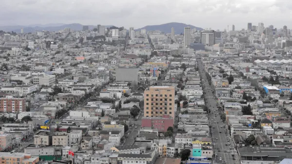
Over the heckles of hundreds of residents opposed to higher density and the two regional planning agencies making the decision, the Bay Area's growth plan designed to cut carbon emissions 15% by 2040 through better planning was approved.

Laura Dixon and the Bay City News Service write about the "marathon joint meeting of the Metropolitan Transportation Commission (MTC) and the Association of Bay Area Governments (ABAG) at the Oakland Marriott" on July 18. The controversial Plan Bay Area was approved late Thursday night over the protests of hundreds of Marin, some of whom had arrived by chartered bus, and Santa Clara residents, many who argued that "such a plan should be subject to a public vote". Others claimed that "the plan would give the government undue authority to dictate where and how communities are allowed to develop housing." Still others charged the plan represented "social engineering" and "a plot to force low-income housing on wealthy communities".
Other groups, including Oakland-based TransForm, successfully asked for more funding for affordable housing and public transit funding.
Jeremy Madsen, executive director of the regional conservation organization, Greenbelt Alliance that's also behind the initiative, Grow Smart Bay Area, wrote, "One of the big (and pleasant) surprises from the night was the inclusion of an amendment that links funds from the One Bay Area Grant program to the production, acquisition, and rehabilitation of affordable homes."
According to Madsen, highlights from the plan include:
- No sprawl for 30 years—100% of new growth will be within existing urban boundaries
- Nearly 80% of new homes and over 60% of new jobs will be near public transit
With approval by the region's metropolitan planning organization (MTC) and coalition of governments (ABAG), the Bay Area joins the San Diego, Los Angeles and Sacramento regions in adopting regional growth plans that comply with the 2008 state law, SB 375.
FULL STORY: Bay Area leaders adopt regional plan to accommodate future population growth

Gentrification and the Bay Area's Controversial Growth Management Plan
Is gentrification the inevitable result of land use planning that reduces greenhouse gas emissions by favoring infill development over auto-dependent sprawl? The Urban Displacement Project looks at the unintended effects of Plan Bay Area.
Density is Key to Fighting Climate Change, Rules Bay Area Judge
A group that coined the term, "stack and pack" to deride density and its role in reducing carbon emissions lost in court when the judge rejected their argument that only technological improvements in cars and fuels were necessary to reduce emissions.
Plan Bay Area: Sued From the Right, Now the Left
Plan Bay Area must be doing something right as it seems to be antagonizing those on both ends of the planning spectrum. First, a libertarian group sues because of "densification", and now environmentalists sue because not enough funds go for transit.

National Parks Layoffs Will Cause Communities to Lose Billions
Thousands of essential park workers were laid off this week, just before the busy spring break season.

Retro-silient?: America’s First “Eco-burb,” The Woodlands Turns 50
A master-planned community north of Houston offers lessons on green infrastructure and resilient design, but falls short of its founder’s lofty affordability and walkability goals.

Delivering for America Plan Will Downgrade Mail Service in at Least 49.5 Percent of Zip Codes
Republican and Democrat lawmakers criticize the plan for its disproportionate negative impact on rural communities.

Test News Post 1
This is a summary

Test News Headline 46
Test for the image on the front page.

Balancing Bombs and Butterflies: How the National Guard Protects a Rare Species
The National Guard at Fort Indiantown Gap uses GIS technology and land management strategies to balance military training with conservation efforts, ensuring the survival of the rare eastern regal fritillary butterfly.
Urban Design for Planners 1: Software Tools
This six-course series explores essential urban design concepts using open source software and equips planners with the tools they need to participate fully in the urban design process.
Planning for Universal Design
Learn the tools for implementing Universal Design in planning regulations.
EMC Planning Group, Inc.
Planetizen
Planetizen
Mpact (formerly Rail~Volution)
Great Falls Development Authority, Inc.
HUDs Office of Policy Development and Research
NYU Wagner Graduate School of Public Service