


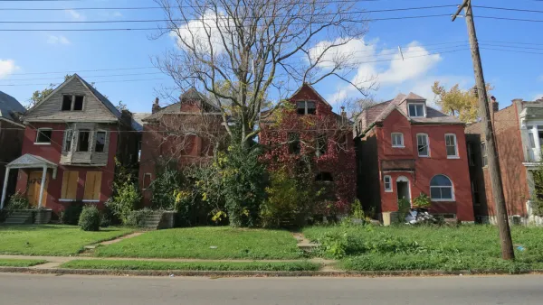
A HUD funded project has provided the city of St. Louis with a fine-grained map of residential real estate conditions across the city. Officials are hopeful the data will better guide the distribution of precious community development dollars.
An approach to neighborhood revitalization pioneered in Philadelphia has made its way to the banks of the Mississippi River, reports Tim Logan. "[St. Louis] on Tuesday unveiled a new 'market value analysis' of city real estate — a pile of housing statistics and maps — that it says will help better target public money, and draw private investment, to neighborhood redevelopment."
"It’s a shift from the old ward-based way of determining how to spend development dollars and move from just using experience, intuition and hunches to decide how to use the city’s limited resources, said Jeff Rainford, chief of staff to Mayor Francis Slay."
Backers don't see the analysis as a replacement for local knowledge, but as an objective supplement to help rationalize investments in community development.
"It’s designed to be the sort of fine-grained analysis that you can feel on a city street but that can get lost from 30,000 feet, said James Heard, director of HUD’s St. Louis field office," notes Logan. "And he hopes it’ll help the city get more bang out of limited federal bucks and make a more sophisticated case to draw private money to redevelopment projects."
FULL STORY: St. Louis turns to data to guide development

The Dark Side of the Rust Belt Revival
Cities in flyover country are facing new redevelopment challenges as companies relocate from costly coastal cities. In St. Louis, downtown revitalization has also brought plans to tackle blight, and the consequences for residents could be immense.
Real-Estate Site Locates Redevelopment Potential Across Philadelphia
A new map-based web tool created by a former city employee calculates the redevelopment potential of every parcel in Philadelphia.
St. Louis Finally Has a Developer for Long-Sought Redevelopment Project
The St. Louis City Council recently approved the initial steps for 1,800 acres of Maryland Heights floodplain. Plenty of hurdles remain, such as coming up with the money the developer wants to see the project through.

National Parks Layoffs Will Cause Communities to Lose Billions
Thousands of essential park workers were laid off this week, just before the busy spring break season.

Retro-silient?: America’s First “Eco-burb,” The Woodlands Turns 50
A master-planned community north of Houston offers lessons on green infrastructure and resilient design, but falls short of its founder’s lofty affordability and walkability goals.

Delivering for America Plan Will Downgrade Mail Service in at Least 49.5 Percent of Zip Codes
Republican and Democrat lawmakers criticize the plan for its disproportionate negative impact on rural communities.

Test News Post 1
This is a summary

Test News Headline 46
Test for the image on the front page.

Balancing Bombs and Butterflies: How the National Guard Protects a Rare Species
The National Guard at Fort Indiantown Gap uses GIS technology and land management strategies to balance military training with conservation efforts, ensuring the survival of the rare eastern regal fritillary butterfly.
Urban Design for Planners 1: Software Tools
This six-course series explores essential urban design concepts using open source software and equips planners with the tools they need to participate fully in the urban design process.
Planning for Universal Design
Learn the tools for implementing Universal Design in planning regulations.
EMC Planning Group, Inc.
Planetizen
Planetizen
Mpact (formerly Rail~Volution)
Great Falls Development Authority, Inc.
HUDs Office of Policy Development and Research
NYU Wagner Graduate School of Public Service