


Walk Score has published its analysis of the quality of public transit in 50 of the biggest cities in the United States. The rankings may surprise you.
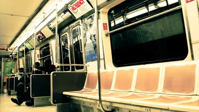
"Upon first glance, the rankings don't seem too surprising. New York City comes in first, as it always should. Boston is the second top-ranked Northeastern city. Washington D.C. is the top Southern city, and San Francisco is the top Western city," observes Ariel Schwartz. But she finds fault with the country's overall rankings.
"Somehow, San Francisco comes in second place after New York City. If that's actually the case, the U.S. transportation system is in big trouble. Because while San Francisco is served by many different transit types (subway, light rail, buses), it still can take hours to cross the seven mile by seven mile city using public transportation."
How was San Francisco able to claim a top spot? Walk Score explains its methodology thus: "To calculate a Transit Score, we assign a "usefulness" value to nearby transit routes based on the frequency, type of route (rail, bus, etc.), and distance to the nearest stop on the route. The "usefulness" of all nearby routes is summed and normalized to a score between 0 - 100."
FULL STORY: The Cities With The Best Public Transportation In The U.S.

The Best Cities for Public Transit
Redfin released its updated transit scores for 2019 and, while there’s little change in the ranking, cities like D.C. and New York did see changes in their scores.
America's Top Ten Transit Meccas
Real estate's favorite tool for gauging neighborhood walkability now has a companion for transit, Kaid Benfield reports.
U.S. Transit Agencies Still in Need of a Long-Term Solution to the Looming ‘Fiscal Cliff’
San Francisco and New York exemplify the political challenges in finding long-term finding solutions for public transit in the post-pandemic United States.

National Parks Layoffs Will Cause Communities to Lose Billions
Thousands of essential park workers were laid off this week, just before the busy spring break season.

Retro-silient?: America’s First “Eco-burb,” The Woodlands Turns 50
A master-planned community north of Houston offers lessons on green infrastructure and resilient design, but falls short of its founder’s lofty affordability and walkability goals.

Delivering for America Plan Will Downgrade Mail Service in at Least 49.5 Percent of Zip Codes
Republican and Democrat lawmakers criticize the plan for its disproportionate negative impact on rural communities.

Test News Post 1
This is a summary

Test News Headline 46
Test for the image on the front page.

Balancing Bombs and Butterflies: How the National Guard Protects a Rare Species
The National Guard at Fort Indiantown Gap uses GIS technology and land management strategies to balance military training with conservation efforts, ensuring the survival of the rare eastern regal fritillary butterfly.
Urban Design for Planners 1: Software Tools
This six-course series explores essential urban design concepts using open source software and equips planners with the tools they need to participate fully in the urban design process.
Planning for Universal Design
Learn the tools for implementing Universal Design in planning regulations.
EMC Planning Group, Inc.
Planetizen
Planetizen
Mpact (formerly Rail~Volution)
Great Falls Development Authority, Inc.
HUDs Office of Policy Development and Research
NYU Wagner Graduate School of Public Service