


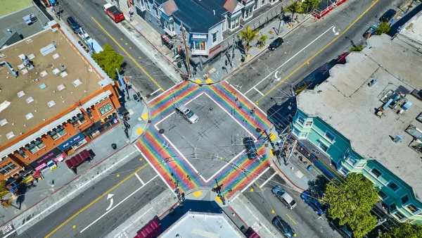
With its own “Vision Zero” goals in place to eliminate pedestrian fatalities within a decade, San Francisco has developed the WalkFirst plan to target the most dangerous intersections in the city for safety improvements.
Jessica Kwong reports on the unveiling of a five-year program, called WalkFirst, to improve safety at San Francisco’s least safe intersections.
Targetting intersections in downtown, the Tenderloin, and South of Market, “WalkFirst seeks to implement a Pedestrian Safety Capital Improvement Program to address corridors and intersections that represent 6 percent of city street miles but account for 60 percent of severe and fatal injuries.”
The city will require more funding to cover the costs of the program. “But the $17 million over five years secured so far for WalkFirst is not enough to cover the improvements needed. Measures in the works for the November ballot could boost that to $50 million, which would cover the capital improvement program costs, but $240 million is needed to implement all the needed projects under the initiative.”
The $17 million the city has to spend in the next five years? That’s about what the city spends treating pedestrian injuries every year, according to Walk San Francisco Executive Director Nicole Schneider.
FULL STORY: SF announcing more plans to boost pedestrian safety

San Francisco Implements ‘Daylighting’ at Intersections
Vehicles are prohibited from parking within 20 feet of a crosswalk as part of the city’s Vision Zero efforts to eliminate traffic deaths and make roads safer.
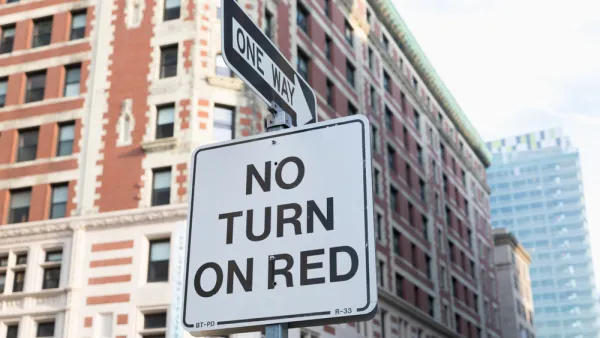
San Francisco Moves to Ban Right Turns on Red
The policy is common in many countries, New York City, and other dense urban areas with high numbers of pedestrians and cyclists.
San Francisco Will Lower Speed Limits on 23 Streets
A 2021 state law allows cities to reduce speed limits next to ‘business activity districts.’

National Parks Layoffs Will Cause Communities to Lose Billions
Thousands of essential park workers were laid off this week, just before the busy spring break season.

Retro-silient?: America’s First “Eco-burb,” The Woodlands Turns 50
A master-planned community north of Houston offers lessons on green infrastructure and resilient design, but falls short of its founder’s lofty affordability and walkability goals.

Delivering for America Plan Will Downgrade Mail Service in at Least 49.5 Percent of Zip Codes
Republican and Democrat lawmakers criticize the plan for its disproportionate negative impact on rural communities.

Test News Post 1
This is a summary

Test News Headline 46
Test for the image on the front page.

Balancing Bombs and Butterflies: How the National Guard Protects a Rare Species
The National Guard at Fort Indiantown Gap uses GIS technology and land management strategies to balance military training with conservation efforts, ensuring the survival of the rare eastern regal fritillary butterfly.
Urban Design for Planners 1: Software Tools
This six-course series explores essential urban design concepts using open source software and equips planners with the tools they need to participate fully in the urban design process.
Planning for Universal Design
Learn the tools for implementing Universal Design in planning regulations.
EMC Planning Group, Inc.
Planetizen
Planetizen
Mpact (formerly Rail~Volution)
Great Falls Development Authority, Inc.
HUDs Office of Policy Development and Research
NYU Wagner Graduate School of Public Service